|
|
|||||||||||||||||
| Point ID: 8428 | Downloads | Plots | Site Data | Code: 10098 |
|
|
|||||||||||||||||
| Download | |
|---|---|
| Site Descriptor Information | Site Time Series Data |
| Link to all available data | |
|
|
| View: | Statistics | Time Series |
| Units: | mm |
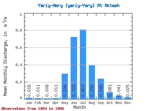
| Statistic | Jan | Feb | Mar | Apr | May | Jun | Jul | Aug | Sep | Oct | Nov | Dec | Annual |
|---|---|---|---|---|---|---|---|---|---|---|---|---|---|
| Mean | 0.02 | 0.01 | 0.01 | 0.01 | 0.30 | 0.72 | 0.81 | 0.39 | 0.24 | 0.08 | 0.04 | 0.03 | 0.22 |
| Standard Deviation | 0.01 | 0.01 | 0.01 | 0.01 | 0.23 | 0.32 | 0.60 | 0.18 | 0.15 | 0.03 | 0.01 | 0.00 | 0.11 |
| Min | 0.01 | 0.00 | 0.00 | 0.01 | 0.03 | 0.48 | 0.30 | 0.29 | 0.15 | 0.05 | 0.03 | 0.02 | 0.14 |
| Max | 0.02 | 0.02 | 0.02 | 0.01 | 0.44 | 1.09 | 1.47 | 0.60 | 0.41 | 0.10 | 0.05 | 0.03 | 0.35 |
| Coefficient of Variation | 0.51 | 0.77 | 0.89 | 0.47 | 0.79 | 0.45 | 0.74 | 0.46 | 0.61 | 0.32 | 0.17 | 0.10 | 0.51 |
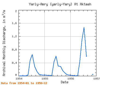
| Year | Jan | Feb | Mar | Apr | May | Jun | Jul | Aug | Sep | Oct | Nov | Dec | Annual | 1954 | 0.01 | 0.00 | 0.00 | 0.01 | 0.03 | 0.48 | 0.65 | 0.29 | 0.15 | 0.05 | 0.03 | 0.03 | 0.14 | 1955 | 0.02 | 0.02 | 0.02 | 0.01 | 0.42 | 0.60 | 0.30 | 0.29 | 0.16 | 0.10 | 0.04 | 0.03 | 0.17 | 1956 | 0.02 | 0.01 | 0.00 | 0.01 | 0.44 | 1.09 | 1.47 | 0.60 | 0.41 | 0.09 | 0.05 | 0.02 | 0.35 |
|---|
 Return to R-Arctic Net Home Page