|
|
|||||||||||||||||
| Point ID: 8428 | Downloads | Plots | Site Data | Code: 10098 |
|
|
|||||||||||||||||
| Download | |
|---|---|
| Site Descriptor Information | Site Time Series Data |
| Link to all available data | |
|
|
| View: | Statistics | Time Series |
| Units: | m3/s |
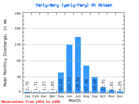
| Statistic | Jan | Feb | Mar | Apr | May | Jun | Jul | Aug | Sep | Oct | Nov | Dec | Annual |
|---|---|---|---|---|---|---|---|---|---|---|---|---|---|
| Mean | 2.67 | 1.65 | 1.41 | 1.83 | 50.76 | 120.19 | 138.48 | 67.52 | 39.88 | 13.90 | 6.76 | 4.23 | 446.86 |
| Standard Deviation | 1.36 | 1.27 | 1.25 | 0.86 | 39.98 | 53.70 | 103.09 | 30.73 | 24.48 | 4.38 | 1.17 | 0.43 | 229.49 |
| Min | 1.20 | 0.63 | 0.69 | 0.83 | 4.63 | 79.75 | 51.50 | 49.78 | 24.92 | 8.93 | 5.65 | 3.78 | 291.32 |
| Max | 3.88 | 3.07 | 2.85 | 2.33 | 75.53 | 181.11 | 252.35 | 103.00 | 68.12 | 17.17 | 7.97 | 4.63 | 710.44 |
| Coefficient of Variation | 0.51 | 0.77 | 0.89 | 0.47 | 0.79 | 0.45 | 0.74 | 0.46 | 0.61 | 0.32 | 0.17 | 0.10 | 0.51 |
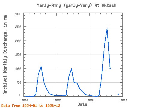
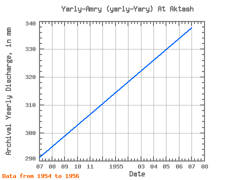
| Year | Jan | Feb | Mar | Apr | May | Jun | Jul | Aug | Sep | Oct | Nov | Dec | Annual | 1954 | 1.20 | 0.63 | 0.69 | 0.83 | 4.63 | 79.75 | 111.58 | 49.78 | 24.92 | 8.93 | 5.65 | 4.29 | 291.32 | 1955 | 3.88 | 3.07 | 2.85 | 2.33 | 72.10 | 99.69 | 51.50 | 49.78 | 26.59 | 17.17 | 6.65 | 4.63 | 338.83 | 1956 | 2.92 | 1.25 | 0.69 | 2.33 | 75.53 | 181.11 | 252.35 | 103.00 | 68.12 | 15.62 | 7.97 | 3.78 | 710.44 |
|---|
 Return to R-Arctic Net Home Page