|
|
|||||||||||||||||
| Point ID: 8419 | Downloads | Plots | Site Data | Code: 10052 |
|
|
|||||||||||||||||
| Download | |
|---|---|
| Site Descriptor Information | Site Time Series Data |
| Link to all available data | |
|
|
| View: | Statistics | Time Series |
| Units: | mm |
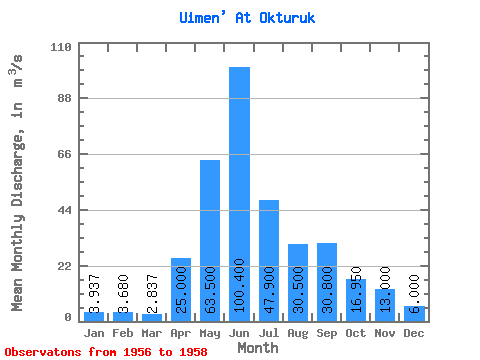
| Statistic | Jan | Feb | Mar | Apr | May | Jun | Jul | Aug | Sep | Oct | Nov | Dec | Annual |
|---|---|---|---|---|---|---|---|---|---|---|---|---|---|
| Mean | 3.94 | 3.68 | 2.84 | 25.00 | 63.50 | 100.40 | 47.90 | 30.50 | 30.80 | 16.95 | 13.00 | 6.00 | 28.68 |
| Standard Deviation | 0.12 | 0.11 | 0.38 | 14.28 | 12.59 | 13.58 | 0.00 | 3.82 | 9.90 | 1.77 | 0.00 | 0.00 | 2.44 |
| Min | 3.80 | 3.57 | 2.46 | 14.90 | 54.60 | 90.80 | 47.90 | 27.80 | 23.80 | 15.70 | 13.00 | 6.00 | 26.96 |
| Max | 4.01 | 3.79 | 3.21 | 35.10 | 72.40 | 110.00 | 47.90 | 33.20 | 37.80 | 18.20 | 13.00 | 6.00 | 30.41 |
| Coefficient of Variation | 0.03 | 0.03 | 0.13 | 0.57 | 0.20 | 0.14 | 0.00 | 0.12 | 0.32 | 0.10 | 0.00 | 0.00 | 0.09 |
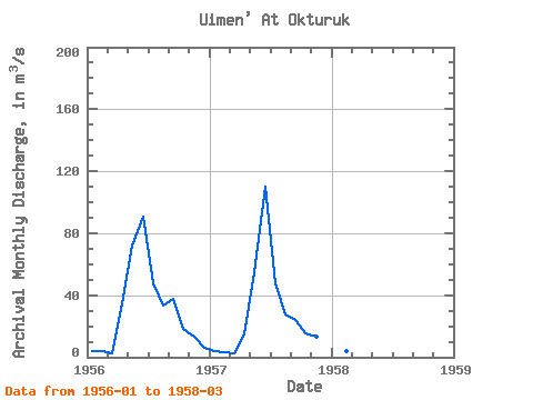
| Year | Jan | Feb | Mar | Apr | May | Jun | Jul | Aug | Sep | Oct | Nov | Dec | Annual | 1956 | 4.00 | 3.68 | 2.84 | 35.10 | 72.40 | 90.80 | 47.90 | 33.20 | 37.80 | 18.20 | 13.00 | 6.00 | 30.41 | 1957 | 3.80 | 3.57 | 2.46 | 14.90 | 54.60 | 110.00 | 47.90 | 27.80 | 23.80 | 15.70 | 13.00 | 6.00 | 26.96 | 1958 | 4.01 | 3.79 | 3.21 |
|---|
 Return to R-Arctic Net Home Page