|
|
|||||||||||||||||
| Point ID: 8419 | Downloads | Plots | Site Data | Code: 10052 |
|
|
|||||||||||||||||
| Download | |
|---|---|
| Site Descriptor Information | Site Time Series Data |
| Link to all available data | |
|
|
| View: | Statistics | Time Series |
| Units: | m3/s |
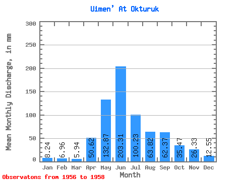
| Statistic | Jan | Feb | Mar | Apr | May | Jun | Jul | Aug | Sep | Oct | Nov | Dec | Annual |
|---|---|---|---|---|---|---|---|---|---|---|---|---|---|
| Mean | 8.24 | 7.01 | 5.94 | 50.62 | 132.85 | 203.31 | 100.22 | 63.81 | 62.37 | 35.46 | 26.32 | 12.55 | 707.27 |
| Standard Deviation | 0.25 | 0.21 | 0.79 | 28.92 | 26.33 | 27.49 | 0.00 | 7.99 | 20.05 | 3.70 | 0.00 | 0.00 | 60.13 |
| Min | 7.95 | 6.80 | 5.15 | 30.17 | 114.23 | 183.87 | 100.22 | 58.16 | 48.20 | 32.85 | 26.32 | 12.55 | 664.75 |
| Max | 8.39 | 7.22 | 6.72 | 71.08 | 151.47 | 222.75 | 100.22 | 69.46 | 76.55 | 38.08 | 26.32 | 12.55 | 749.80 |
| Coefficient of Variation | 0.03 | 0.03 | 0.13 | 0.57 | 0.20 | 0.14 | 0.00 | 0.12 | 0.32 | 0.10 | 0.00 | 0.00 | 0.09 |
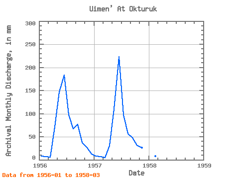
| Year | Jan | Feb | Mar | Apr | May | Jun | Jul | Aug | Sep | Oct | Nov | Dec | Annual | 1956 | 8.37 | 7.01 | 5.94 | 71.08 | 151.47 | 183.87 | 100.22 | 69.46 | 76.55 | 38.08 | 26.32 | 12.55 | 749.80 | 1957 | 7.95 | 6.80 | 5.15 | 30.17 | 114.23 | 222.75 | 100.22 | 58.16 | 48.20 | 32.85 | 26.32 | 12.55 | 664.75 | 1958 | 8.39 | 7.22 | 6.72 |
|---|
 Return to R-Arctic Net Home Page