|
|
|||||||||||||||||
| Point ID: 8415 | Downloads | Plots | Site Data | Code: 9553 |
|
|
|||||||||||||||||
| Download | |
|---|---|
| Site Descriptor Information | Site Time Series Data |
| Link to all available data | |
|
|
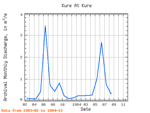
| View: | Statistics | Time Series |
| Units: | mm |
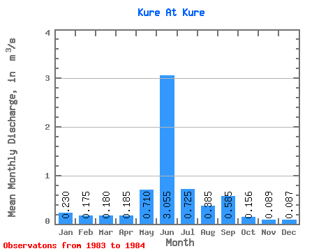
| Statistic | Jan | Feb | Mar | Apr | May | Jun | Jul | Aug | Sep | Oct | Nov | Dec | Annual |
|---|---|---|---|---|---|---|---|---|---|---|---|---|---|
| Mean | 0.23 | 0.17 | 0.18 | 0.18 | 0.71 | 3.06 | 0.72 | 0.39 | 0.58 | 0.16 | 0.09 | 0.09 | 0.52 |
| Standard Deviation | 0.08 | 0.10 | 0.12 | 0.40 | 0.53 | 0.02 | 0.08 | 0.32 | 0.10 | 0.03 | 0.06 | ||
| Min | 0.23 | 0.12 | 0.11 | 0.10 | 0.43 | 2.68 | 0.71 | 0.33 | 0.36 | 0.08 | 0.07 | 0.04 | 0.52 |
| Max | 0.23 | 0.23 | 0.25 | 0.27 | 0.99 | 3.43 | 0.74 | 0.44 | 0.81 | 0.23 | 0.11 | 0.13 | 0.52 |
| Coefficient of Variation | 0.44 | 0.55 | 0.65 | 0.56 | 0.17 | 0.03 | 0.20 | 0.54 | 0.67 | 0.34 | 0.69 |
| Year | Jan | Feb | Mar | Apr | May | Jun | Jul | Aug | Sep | Oct | Nov | Dec | Annual | 1983 | 0.12 | 0.11 | 0.10 | 0.43 | 3.43 | 0.71 | 0.44 | 0.81 | 0.23 | 0.11 | 0.13 | 1984 | 0.23 | 0.23 | 0.25 | 0.27 | 0.99 | 2.68 | 0.74 | 0.33 | 0.36 | 0.08 | 0.07 | 0.04 | 0.52 |
|---|
 Return to R-Arctic Net Home Page