|
|
|||||||||||||||||
| Point ID: 8415 | Downloads | Plots | Site Data | Code: 9553 |
|
|
|||||||||||||||||
| Download | |
|---|---|
| Site Descriptor Information | Site Time Series Data |
| Link to all available data | |
|
|
| View: | Statistics | Time Series |
| Units: | m3/s |
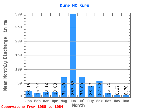
| Statistic | Jan | Feb | Mar | Apr | May | Jun | Jul | Aug | Sep | Oct | Nov | Dec | Annual |
|---|---|---|---|---|---|---|---|---|---|---|---|---|---|
| Mean | 23.16 | 16.05 | 18.12 | 18.03 | 71.48 | 297.69 | 72.99 | 38.76 | 57.01 | 15.71 | 8.62 | 8.81 | 620.32 |
| Standard Deviation | 7.13 | 9.97 | 11.71 | 39.87 | 51.68 | 2.14 | 7.83 | 31.01 | 10.54 | 2.96 | 6.05 | ||
| Min | 23.16 | 11.01 | 11.07 | 9.74 | 43.29 | 261.15 | 71.48 | 33.22 | 35.08 | 8.26 | 6.53 | 4.53 | 620.32 |
| Max | 23.16 | 21.10 | 25.17 | 26.31 | 99.67 | 334.23 | 74.50 | 44.30 | 78.93 | 23.16 | 10.72 | 13.09 | 620.32 |
| Coefficient of Variation | 0.44 | 0.55 | 0.65 | 0.56 | 0.17 | 0.03 | 0.20 | 0.54 | 0.67 | 0.34 | 0.69 |
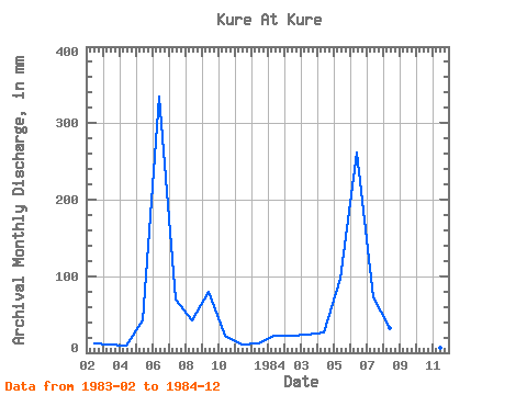
| Year | Jan | Feb | Mar | Apr | May | Jun | Jul | Aug | Sep | Oct | Nov | Dec | Annual | 1983 | 11.01 | 11.07 | 9.74 | 43.29 | 334.23 | 71.48 | 44.30 | 78.93 | 23.16 | 10.72 | 13.09 | 1984 | 23.16 | 21.10 | 25.17 | 26.31 | 99.67 | 261.15 | 74.50 | 33.22 | 35.08 | 8.26 | 6.53 | 4.53 | 620.32 |
|---|
 Return to R-Arctic Net Home Page