|
|
|||||||||||||||||
| Point ID: 8412 | Downloads | Plots | Site Data | Code: 9550 |
|
|
|||||||||||||||||
| Download | |
|---|---|
| Site Descriptor Information | Site Time Series Data |
| Link to all available data | |
|
|
| View: | Statistics | Time Series |
| Units: | mm |
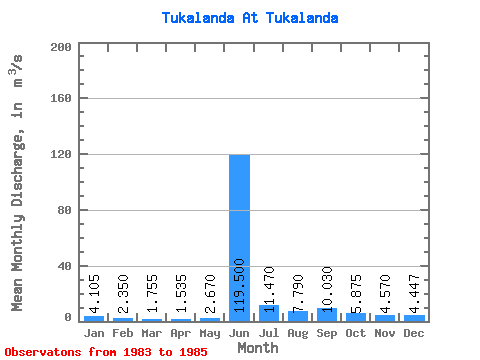
| Statistic | Jan | Feb | Mar | Apr | May | Jun | Jul | Aug | Sep | Oct | Nov | Dec | Annual |
|---|---|---|---|---|---|---|---|---|---|---|---|---|---|
| Mean | 4.11 | 2.35 | 1.75 | 1.54 | 2.67 | 119.50 | 11.47 | 7.79 | 10.03 | 5.88 | 4.57 | 4.45 | 14.52 |
| Standard Deviation | 2.45 | 1.74 | 1.56 | 1.24 | 0.10 | 26.16 | 2.59 | 0.06 | 2.36 | 1.31 | 0.52 | 3.34 | 3.08 |
| Min | 2.37 | 1.12 | 0.65 | 0.66 | 2.60 | 101.00 | 9.64 | 7.75 | 8.36 | 4.95 | 4.20 | 2.01 | 12.34 |
| Max | 5.84 | 3.58 | 2.86 | 2.41 | 2.74 | 138.00 | 13.30 | 7.83 | 11.70 | 6.80 | 4.94 | 8.26 | 16.70 |
| Coefficient of Variation | 0.60 | 0.74 | 0.89 | 0.81 | 0.04 | 0.22 | 0.23 | 0.01 | 0.23 | 0.22 | 0.11 | 0.75 | 0.21 |
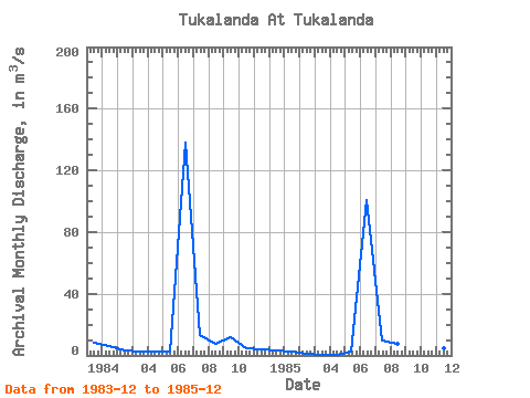
| Year | Jan | Feb | Mar | Apr | May | Jun | Jul | Aug | Sep | Oct | Nov | Dec | Annual | 1983 | 8.26 | 1984 | 5.84 | 3.58 | 2.86 | 2.41 | 2.60 | 138.00 | 13.30 | 7.83 | 11.70 | 4.95 | 4.20 | 3.07 | 16.70 | 1985 | 2.37 | 1.12 | 0.65 | 0.66 | 2.74 | 101.00 | 9.64 | 7.75 | 8.36 | 6.80 | 4.94 | 2.01 | 12.34 |
|---|
 Return to R-Arctic Net Home Page