|
|
|||||||||||||||||
| Point ID: 8412 | Downloads | Plots | Site Data | Code: 9550 |
|
|
|||||||||||||||||
| Download | |
|---|---|
| Site Descriptor Information | Site Time Series Data |
| Link to all available data | |
|
|
| View: | Statistics | Time Series |
| Units: | m3/s |
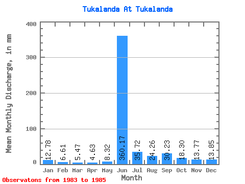
| Statistic | Jan | Feb | Mar | Apr | May | Jun | Jul | Aug | Sep | Oct | Nov | Dec | Annual |
|---|---|---|---|---|---|---|---|---|---|---|---|---|---|
| Mean | 12.78 | 6.67 | 5.46 | 4.63 | 8.31 | 360.17 | 35.72 | 24.26 | 30.23 | 18.29 | 13.77 | 13.85 | 532.70 |
| Standard Deviation | 7.64 | 4.94 | 4.87 | 3.73 | 0.31 | 78.85 | 8.06 | 0.18 | 7.12 | 4.07 | 1.58 | 10.41 | 113.09 |
| Min | 7.38 | 3.18 | 2.02 | 1.99 | 8.10 | 304.41 | 30.02 | 24.13 | 25.20 | 15.41 | 12.66 | 6.26 | 452.73 |
| Max | 18.18 | 10.16 | 8.91 | 7.26 | 8.53 | 415.93 | 41.42 | 24.38 | 35.26 | 21.18 | 14.89 | 25.72 | 612.67 |
| Coefficient of Variation | 0.60 | 0.74 | 0.89 | 0.81 | 0.04 | 0.22 | 0.23 | 0.01 | 0.23 | 0.22 | 0.11 | 0.75 | 0.21 |
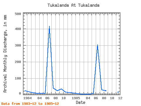
| Year | Jan | Feb | Mar | Apr | May | Jun | Jul | Aug | Sep | Oct | Nov | Dec | Annual | 1983 | 25.72 | 1984 | 18.18 | 10.16 | 8.91 | 7.26 | 8.10 | 415.93 | 41.42 | 24.38 | 35.26 | 15.41 | 12.66 | 9.56 | 612.67 | 1985 | 7.38 | 3.18 | 2.02 | 1.99 | 8.53 | 304.41 | 30.02 | 24.13 | 25.20 | 21.18 | 14.89 | 6.26 | 452.73 |
|---|
 Return to R-Arctic Net Home Page