|
|
|||||||||||||||||
| Point ID: 8411 | Downloads | Plots | Site Data | Code: 9549 |
|
|
|||||||||||||||||
| Download | |
|---|---|
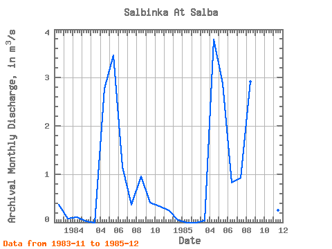
| Site Descriptor Information | Site Time Series Data |
| Link to all available data | |
|
|
| View: | Statistics | Time Series |
| Units: | mm |
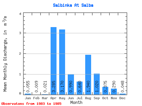
| Statistic | Jan | Feb | Mar | Apr | May | Jun | Jul | Aug | Sep | Oct | Nov | Dec | Annual |
|---|---|---|---|---|---|---|---|---|---|---|---|---|---|
| Mean | 0.06 | 0.01 | 0.02 | 3.29 | 3.17 | 0.99 | 0.64 | 1.94 | 1.02 | 0.38 | 0.29 | 0.05 | 0.98 |
| Standard Deviation | 0.08 | 0.01 | 0.03 | 0.71 | 0.41 | 0.23 | 0.40 | 1.39 | 0.86 | 0.06 | 0.07 | 0.03 | 0.23 |
| Min | 0.00 | 0.00 | 0.00 | 2.78 | 2.88 | 0.83 | 0.36 | 0.96 | 0.41 | 0.33 | 0.25 | 0.01 | 0.82 |
| Max | 0.11 | 0.02 | 0.04 | 3.79 | 3.46 | 1.15 | 0.92 | 2.92 | 1.63 | 0.42 | 0.37 | 0.08 | 1.14 |
| Coefficient of Variation | 1.41 | 1.41 | 1.41 | 0.22 | 0.13 | 0.23 | 0.62 | 0.71 | 0.85 | 0.17 | 0.24 | 0.69 | 0.23 |
| Year | Jan | Feb | Mar | Apr | May | Jun | Jul | Aug | Sep | Oct | Nov | Dec | Annual | 1983 | 0.37 | 0.08 | 1984 | 0.11 | 0.02 | 0.00 | 2.78 | 3.46 | 1.15 | 0.36 | 0.96 | 0.41 | 0.33 | 0.25 | 0.05 | 0.82 | 1985 | 0.00 | 0.00 | 0.04 | 3.79 | 2.88 | 0.83 | 0.92 | 2.92 | 1.63 | 0.42 | 0.25 | 0.01 | 1.14 |
|---|
 Return to R-Arctic Net Home Page