|
|
|||||||||||||||||
| Point ID: 8411 | Downloads | Plots | Site Data | Code: 9549 |
|
|
|||||||||||||||||
| Download | |
|---|---|
| Site Descriptor Information | Site Time Series Data |
| Link to all available data | |
|
|
| View: | Statistics | Time Series |
| Units: | m3/s |
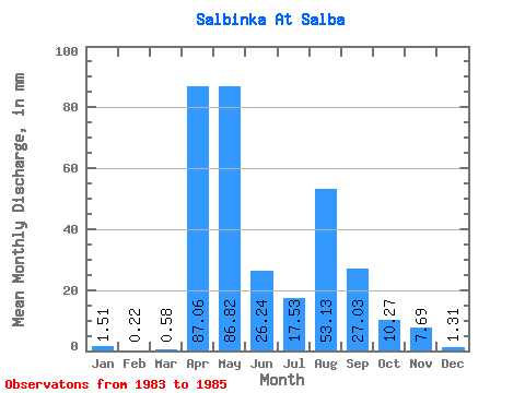
| Statistic | Jan | Feb | Mar | Apr | May | Jun | Jul | Aug | Sep | Oct | Nov | Dec | Annual |
|---|---|---|---|---|---|---|---|---|---|---|---|---|---|
| Mean | 1.51 | 0.24 | 0.56 | 87.06 | 86.80 | 26.24 | 17.52 | 53.12 | 27.03 | 10.27 | 7.69 | 1.30 | 316.96 |
| Standard Deviation | 2.13 | 0.34 | 0.79 | 18.93 | 11.23 | 6.00 | 10.84 | 37.95 | 22.86 | 1.74 | 1.84 | 0.90 | 72.58 |
| Min | 0.00 | 0.00 | 0.00 | 73.68 | 78.86 | 22.00 | 9.86 | 26.29 | 10.87 | 9.04 | 6.63 | 0.38 | 265.63 |
| Max | 3.01 | 0.47 | 1.12 | 100.45 | 94.74 | 30.48 | 25.19 | 79.96 | 43.20 | 11.50 | 9.81 | 2.19 | 368.28 |
| Coefficient of Variation | 1.41 | 1.41 | 1.41 | 0.22 | 0.13 | 0.23 | 0.62 | 0.71 | 0.85 | 0.17 | 0.24 | 0.69 | 0.23 |
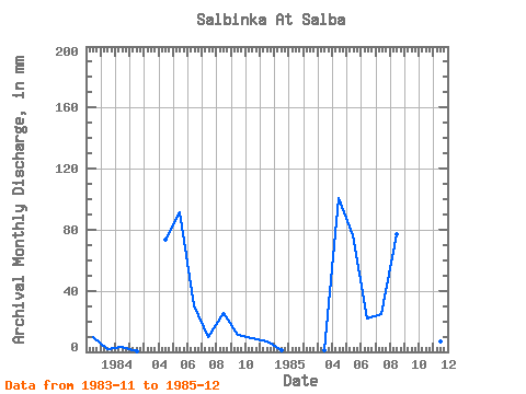
| Year | Jan | Feb | Mar | Apr | May | Jun | Jul | Aug | Sep | Oct | Nov | Dec | Annual | 1983 | 9.81 | 2.19 | 1984 | 3.01 | 0.47 | 0.00 | 73.68 | 94.74 | 30.48 | 9.86 | 26.29 | 10.87 | 9.04 | 6.63 | 1.34 | 265.63 | 1985 | 0.00 | 0.00 | 1.12 | 100.45 | 78.86 | 22.00 | 25.19 | 79.96 | 43.20 | 11.50 | 6.63 | 0.38 | 368.28 |
|---|
 Return to R-Arctic Net Home Page