|
|
|||||||||||||||||
| Point ID: 8410 | Downloads | Plots | Site Data | Code: 9548 |
|
|
|||||||||||||||||
| Download | |
|---|---|
| Site Descriptor Information | Site Time Series Data |
| Link to all available data | |

|
|
| View: | Statistics | Time Series |
| Units: | mm |
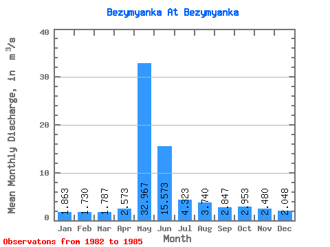
| Statistic | Jan | Feb | Mar | Apr | May | Jun | Jul | Aug | Sep | Oct | Nov | Dec | Annual |
|---|---|---|---|---|---|---|---|---|---|---|---|---|---|
| Mean | 1.86 | 1.73 | 1.79 | 2.57 | 32.97 | 15.57 | 4.32 | 3.74 | 2.85 | 2.95 | 2.48 | 2.05 | 6.27 |
| Standard Deviation | 0.14 | 0.27 | 0.21 | 1.34 | 1.01 | 6.81 | 2.02 | 1.96 | 0.97 | 1.37 | 0.73 | 0.27 | 0.55 |
| Min | 1.75 | 1.52 | 1.65 | 1.62 | 31.90 | 9.82 | 2.38 | 2.16 | 2.19 | 2.15 | 2.08 | 1.83 | 5.64 |
| Max | 2.02 | 2.03 | 2.03 | 4.11 | 33.90 | 23.10 | 6.42 | 5.94 | 3.96 | 5.01 | 3.58 | 2.43 | 6.66 |
| Coefficient of Variation | 0.07 | 0.15 | 0.12 | 0.52 | 0.03 | 0.44 | 0.47 | 0.53 | 0.34 | 0.47 | 0.30 | 0.13 | 0.09 |
| Year | Jan | Feb | Mar | Apr | May | Jun | Jul | Aug | Sep | Oct | Nov | Dec | Annual | 1982 | 2.15 | 2.08 | 2.05 | 1983 | 2.02 | 2.03 | 2.03 | 1.99 | 33.90 | 23.10 | 2.38 | 2.16 | 2.19 | 2.35 | 2.14 | 1.88 | 6.51 | 1984 | 1.82 | 1.52 | 1.65 | 1.62 | 33.10 | 9.82 | 6.42 | 3.12 | 2.39 | 2.30 | 2.12 | 1.83 | 5.64 | 1985 | 1.75 | 1.64 | 1.68 | 4.11 | 31.90 | 13.80 | 4.17 | 5.94 | 3.96 | 5.01 | 3.58 | 2.43 | 6.66 |
|---|
 Return to R-Arctic Net Home Page