|
|
|||||||||||||||||
| Point ID: 8410 | Downloads | Plots | Site Data | Code: 9548 |
|
|
|||||||||||||||||
| Download | |
|---|---|
| Site Descriptor Information | Site Time Series Data |
| Link to all available data | |
|
|
| View: | Statistics | Time Series |
| Units: | m3/s |
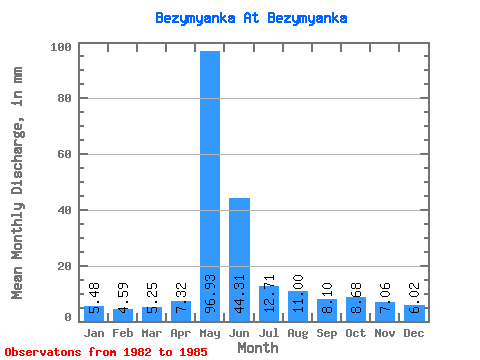
| Statistic | Jan | Feb | Mar | Apr | May | Jun | Jul | Aug | Sep | Oct | Nov | Dec | Annual |
|---|---|---|---|---|---|---|---|---|---|---|---|---|---|
| Mean | 5.48 | 4.63 | 5.25 | 7.32 | 96.91 | 44.31 | 12.71 | 10.99 | 8.10 | 8.68 | 7.06 | 6.02 | 217.34 |
| Standard Deviation | 0.41 | 0.71 | 0.62 | 3.82 | 2.96 | 19.39 | 5.95 | 5.78 | 2.76 | 4.04 | 2.09 | 0.80 | 19.11 |
| Min | 5.14 | 4.07 | 4.85 | 4.61 | 93.77 | 27.94 | 7.00 | 6.35 | 6.23 | 6.32 | 5.92 | 5.38 | 195.47 |
| Max | 5.94 | 5.44 | 5.97 | 11.69 | 99.65 | 65.72 | 18.87 | 17.46 | 11.27 | 14.73 | 10.19 | 7.14 | 230.87 |
| Coefficient of Variation | 0.07 | 0.15 | 0.12 | 0.52 | 0.03 | 0.44 | 0.47 | 0.53 | 0.34 | 0.47 | 0.30 | 0.13 | 0.09 |
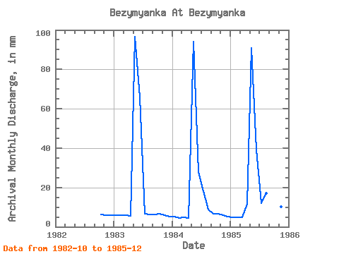
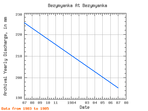
| Year | Jan | Feb | Mar | Apr | May | Jun | Jul | Aug | Sep | Oct | Nov | Dec | Annual | 1982 | 6.32 | 5.92 | 6.03 | 1983 | 5.94 | 5.44 | 5.97 | 5.66 | 99.65 | 65.72 | 7.00 | 6.35 | 6.23 | 6.91 | 6.09 | 5.53 | 225.67 | 1984 | 5.35 | 4.07 | 4.85 | 4.61 | 97.30 | 27.94 | 18.87 | 9.17 | 6.80 | 6.76 | 6.03 | 5.38 | 195.47 | 1985 | 5.14 | 4.39 | 4.94 | 11.69 | 93.77 | 39.26 | 12.26 | 17.46 | 11.27 | 14.73 | 10.19 | 7.14 | 230.87 |
|---|
 Return to R-Arctic Net Home Page