|
|
|||||||||||||||||
| Point ID: 8409 | Downloads | Plots | Site Data | Code: 9547 |
|
|
|||||||||||||||||
| Download | |
|---|---|
| Site Descriptor Information | Site Time Series Data |
| Link to all available data | |
|
|
| View: | Statistics | Time Series |
| Units: | mm |
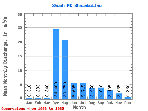
| Statistic | Jan | Feb | Mar | Apr | May | Jun | Jul | Aug | Sep | Oct | Nov | Dec | Annual |
|---|---|---|---|---|---|---|---|---|---|---|---|---|---|
| Mean | 0.32 | 0.29 | 0.34 | 24.40 | 20.75 | 5.61 | 5.71 | 3.95 | 4.01 | 3.10 | 2.04 | 0.83 | 5.91 |
| Standard Deviation | 0.39 | 0.42 | 0.38 | 5.94 | 6.86 | 0.95 | 1.25 | 0.01 | 2.81 | 0.42 | 0.46 | 0.44 | 0.25 |
| Min | 0.04 | 0.00 | 0.00 | 20.20 | 15.90 | 4.93 | 4.83 | 3.94 | 2.02 | 2.81 | 1.71 | 0.52 | 5.73 |
| Max | 0.59 | 0.77 | 0.75 | 28.60 | 25.60 | 6.28 | 6.60 | 3.96 | 6.00 | 3.40 | 2.36 | 1.14 | 6.09 |
| Coefficient of Variation | 1.23 | 1.42 | 1.12 | 0.24 | 0.33 | 0.17 | 0.22 | 0.00 | 0.70 | 0.13 | 0.23 | 0.53 | 0.04 |
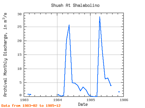
| Year | Jan | Feb | Mar | Apr | May | Jun | Jul | Aug | Sep | Oct | Nov | Dec | Annual | 1983 | 0.77 | 0.75 | 1984 | 0.59 | 0.11 | 0.27 | 20.20 | 25.60 | 4.93 | 4.83 | 3.94 | 2.02 | 3.40 | 2.36 | 0.52 | 5.73 | 1985 | 0.04 | 0.00 | 0.00 | 28.60 | 15.90 | 6.28 | 6.60 | 3.96 | 6.00 | 2.81 | 1.71 | 1.14 | 6.09 |
|---|
 Return to R-Arctic Net Home Page