|
|
|||||||||||||||||
| Point ID: 8409 | Downloads | Plots | Site Data | Code: 9547 |
|
|
|||||||||||||||||
| Download | |
|---|---|
| Site Descriptor Information | Site Time Series Data |
| Link to all available data | |
|
|
| View: | Statistics | Time Series |
| Units: | m3/s |
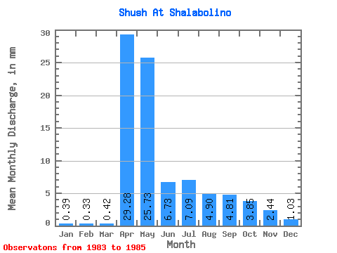
| Statistic | Jan | Feb | Mar | Apr | May | Jun | Jul | Aug | Sep | Oct | Nov | Dec | Annual |
|---|---|---|---|---|---|---|---|---|---|---|---|---|---|
| Mean | 0.39 | 0.33 | 0.42 | 29.28 | 25.73 | 6.73 | 7.09 | 4.90 | 4.81 | 3.85 | 2.44 | 1.03 | 86.33 |
| Standard Deviation | 0.48 | 0.47 | 0.47 | 7.13 | 8.50 | 1.15 | 1.55 | 0.02 | 3.38 | 0.52 | 0.55 | 0.54 | 3.68 |
| Min | 0.05 | 0.00 | 0.00 | 24.24 | 19.71 | 5.92 | 5.99 | 4.88 | 2.42 | 3.48 | 2.05 | 0.65 | 83.73 |
| Max | 0.73 | 0.87 | 0.93 | 34.32 | 31.74 | 7.54 | 8.18 | 4.91 | 7.20 | 4.21 | 2.83 | 1.41 | 88.94 |
| Coefficient of Variation | 1.23 | 1.42 | 1.12 | 0.24 | 0.33 | 0.17 | 0.22 | 0.00 | 0.70 | 0.13 | 0.23 | 0.53 | 0.04 |
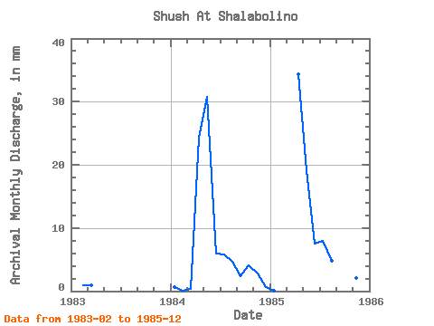
| Year | Jan | Feb | Mar | Apr | May | Jun | Jul | Aug | Sep | Oct | Nov | Dec | Annual | 1983 | 0.87 | 0.93 | 1984 | 0.73 | 0.12 | 0.34 | 24.24 | 31.74 | 5.92 | 5.99 | 4.88 | 2.42 | 4.21 | 2.83 | 0.65 | 83.73 | 1985 | 0.05 | 0.00 | 0.00 | 34.32 | 19.71 | 7.54 | 8.18 | 4.91 | 7.20 | 3.48 | 2.05 | 1.41 | 88.94 |
|---|
 Return to R-Arctic Net Home Page