|
|
|||||||||||||||||
| Point ID: 8394 | Downloads | Plots | Site Data | Code: 9491 |
|
|
|||||||||||||||||
| Download | |
|---|---|
| Site Descriptor Information | Site Time Series Data |
| Link to all available data | |
|
|
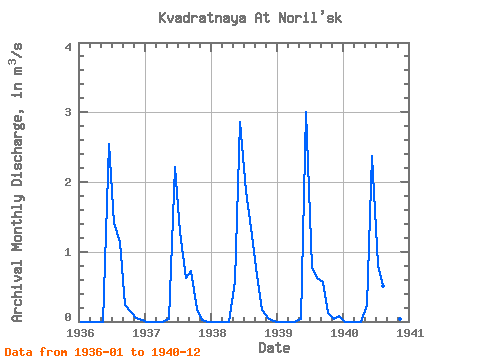
| View: | Statistics | Time Series |
| Units: | mm |
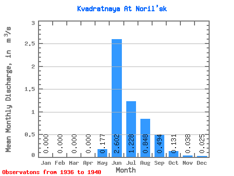
| Statistic | Jan | Feb | Mar | Apr | May | Jun | Jul | Aug | Sep | Oct | Nov | Dec | Annual |
|---|---|---|---|---|---|---|---|---|---|---|---|---|---|
| Mean | 0.00 | 0.00 | 0.00 | 0.00 | 0.18 | 2.60 | 1.23 | 0.85 | 0.49 | 0.13 | 0.04 | 0.03 | 0.46 |
| Standard Deviation | 0.00 | 0.00 | 0.00 | 0.00 | 0.24 | 0.33 | 0.46 | 0.37 | 0.22 | 0.05 | 0.01 | 0.03 | 0.10 |
| Min | 0.00 | 0.00 | 0.00 | 0.00 | 0.00 | 2.22 | 0.77 | 0.51 | 0.24 | 0.06 | 0.02 | 0.00 | 0.36 |
| Max | 0.00 | 0.00 | 0.00 | 0.00 | 0.58 | 3.01 | 1.87 | 1.34 | 0.72 | 0.18 | 0.05 | 0.08 | 0.63 |
| Coefficient of Variation | 1.38 | 0.13 | 0.37 | 0.43 | 0.45 | 0.37 | 0.33 | 1.29 | 0.22 |
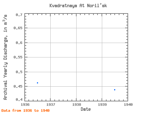
| Year | Jan | Feb | Mar | Apr | May | Jun | Jul | Aug | Sep | Oct | Nov | Dec | Annual | 1936 | 0.00 | 0.00 | 0.00 | 0.00 | 0.00 | 2.55 | 1.41 | 1.14 | 0.24 | 0.13 | 0.05 | 0.02 | 0.46 | 1937 | 0.00 | 0.00 | 0.00 | 0.00 | 0.03 | 2.22 | 1.28 | 0.62 | 0.72 | 0.18 | 0.02 | 0.00 | 0.42 | 1938 | 0.00 | 0.00 | 0.00 | 0.00 | 0.58 | 2.86 | 1.87 | 1.34 | 0.66 | 0.17 | 0.05 | 0.01 | 0.63 | 1939 | 0.00 | 0.00 | 0.00 | 0.00 | 0.04 | 3.01 | 0.77 | 0.63 | 0.57 | 0.12 | 0.04 | 0.08 | 0.44 | 1940 | 0.00 | 0.00 | 0.00 | 0.00 | 0.24 | 2.37 | 0.81 | 0.51 | 0.28 | 0.06 | 0.04 | 0.01 | 0.36 |
|---|
 Return to R-Arctic Net Home Page