|
|
|||||||||||||||||
| Point ID: 8394 | Downloads | Plots | Site Data | Code: 9491 |
|
|
|||||||||||||||||
| Download | |
|---|---|
| Site Descriptor Information | Site Time Series Data |
| Link to all available data | |
|
|
| View: | Statistics | Time Series |
| Units: | m3/s |
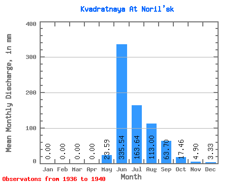
| Statistic | Jan | Feb | Mar | Apr | May | Jun | Jul | Aug | Sep | Oct | Nov | Dec | Annual |
|---|---|---|---|---|---|---|---|---|---|---|---|---|---|
| Mean | 0.00 | 0.00 | 0.00 | 0.00 | 23.64 | 335.54 | 163.61 | 112.98 | 63.70 | 17.51 | 4.95 | 3.28 | 725.38 |
| Standard Deviation | 0.00 | 0.00 | 0.00 | 0.00 | 32.56 | 42.55 | 60.78 | 49.00 | 28.45 | 6.50 | 1.61 | 4.24 | 157.60 |
| Min | 0.00 | 0.00 | 0.00 | 0.00 | 0.00 | 286.28 | 102.59 | 67.95 | 30.95 | 7.59 | 2.58 | 0.00 | 564.60 |
| Max | 0.00 | 0.00 | 0.00 | 0.00 | 77.28 | 388.15 | 249.15 | 178.53 | 92.85 | 23.98 | 6.45 | 10.66 | 986.58 |
| Coefficient of Variation | 1.38 | 0.13 | 0.37 | 0.43 | 0.45 | 0.37 | 0.33 | 1.29 | 0.22 |
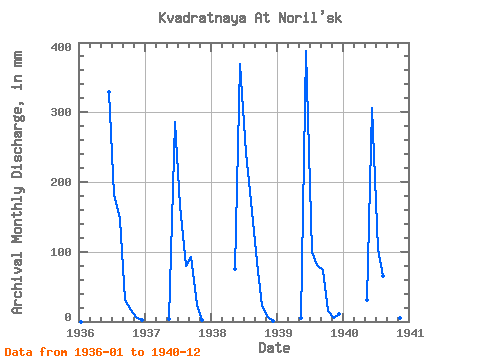
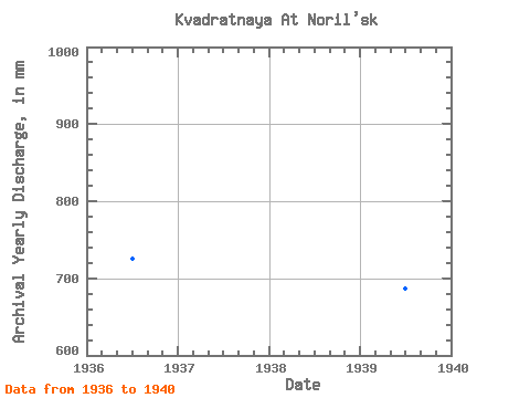
| Year | Jan | Feb | Mar | Apr | May | Jun | Jul | Aug | Sep | Oct | Nov | Dec | Annual | 1936 | 0.00 | 0.00 | 0.00 | 0.00 | 0.00 | 328.84 | 187.86 | 151.89 | 30.95 | 17.32 | 6.45 | 2.67 | 724.89 | 1937 | 0.00 | 0.00 | 0.00 | 0.00 | 4.00 | 286.28 | 170.54 | 82.61 | 92.85 | 23.98 | 2.58 | 0.00 | 663.39 | 1938 | 0.00 | 0.00 | 0.00 | 0.00 | 77.28 | 368.81 | 249.15 | 178.53 | 85.11 | 22.65 | 6.45 | 1.33 | 986.58 | 1939 | 0.00 | 0.00 | 0.00 | 0.00 | 4.93 | 388.15 | 102.59 | 83.94 | 73.50 | 15.99 | 4.77 | 10.66 | 687.46 | 1940 | 0.00 | 0.00 | 0.00 | 0.00 | 31.98 | 305.62 | 107.92 | 67.95 | 36.11 | 7.59 | 4.51 | 1.73 | 564.60 |
|---|
 Return to R-Arctic Net Home Page