|
|
|||||||||||||||||
| Point ID: 8393 | Downloads | Plots | Site Data | Code: 9490 |
|
|
|||||||||||||||||
| Download | |
|---|---|
| Site Descriptor Information | Site Time Series Data |
| Link to all available data | |
|
|
| View: | Statistics | Time Series |
| Units: | mm |
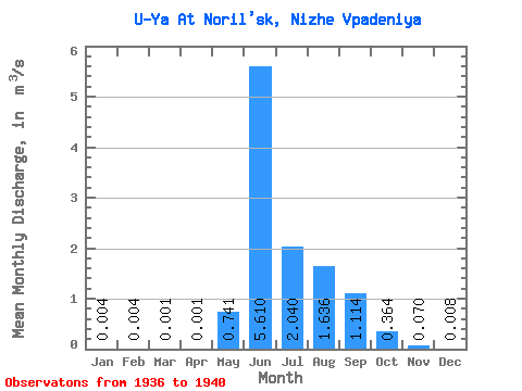
| Statistic | Jan | Feb | Mar | Apr | May | Jun | Jul | Aug | Sep | Oct | Nov | Dec | Annual |
|---|---|---|---|---|---|---|---|---|---|---|---|---|---|
| Mean | 0.00 | 0.00 | 0.00 | 0.00 | 0.74 | 5.61 | 2.04 | 1.64 | 1.11 | 0.36 | 0.07 | 0.01 | 0.97 |
| Standard Deviation | 0.01 | 0.01 | 0.00 | 0.00 | 0.95 | 1.04 | 0.88 | 0.80 | 0.53 | 0.13 | 0.07 | 0.01 | 0.23 |
| Min | 0.00 | 0.00 | 0.00 | 0.00 | 0.01 | 4.87 | 1.36 | 0.77 | 0.48 | 0.20 | 0.02 | 0.00 | 0.75 |
| Max | 0.01 | 0.01 | 0.01 | 0.01 | 2.09 | 7.14 | 3.30 | 2.85 | 1.60 | 0.51 | 0.20 | 0.02 | 1.27 |
| Coefficient of Variation | 1.28 | 1.28 | 2.00 | 2.00 | 1.28 | 0.19 | 0.43 | 0.49 | 0.48 | 0.36 | 1.05 | 1.05 | 0.23 |
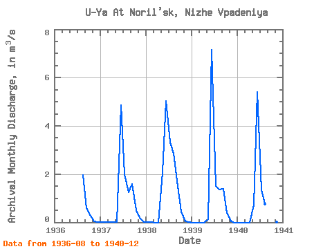
| Year | Jan | Feb | Mar | Apr | May | Jun | Jul | Aug | Sep | Oct | Nov | Dec | Annual | 1936 | 1.96 | 0.60 | 0.26 | 0.04 | 0.01 | 1937 | 0.01 | 0.01 | 0.01 | 0.01 | 0.01 | 4.87 | 1.99 | 1.24 | 1.60 | 0.51 | 0.20 | 0.01 | 0.87 | 1938 | 0.01 | 0.01 | 0.00 | 0.00 | 2.09 | 5.02 | 3.30 | 2.85 | 1.50 | 0.45 | 0.05 | 0.02 | 1.27 | 1939 | 0.00 | 0.00 | 0.00 | 0.00 | 0.14 | 7.14 | 1.51 | 1.36 | 1.39 | 0.40 | 0.04 | 0.00 | 1.00 | 1940 | 0.00 | 0.00 | 0.00 | 0.00 | 0.73 | 5.41 | 1.36 | 0.77 | 0.48 | 0.20 | 0.02 | 0.00 | 0.75 |
|---|
 Return to R-Arctic Net Home Page