|
|
|||||||||||||||||
| Point ID: 8393 | Downloads | Plots | Site Data | Code: 9490 |
|
|
|||||||||||||||||
| Download | |
|---|---|
| Site Descriptor Information | Site Time Series Data |
| Link to all available data | |
|
|
| View: | Statistics | Time Series |
| Units: | m3/s |
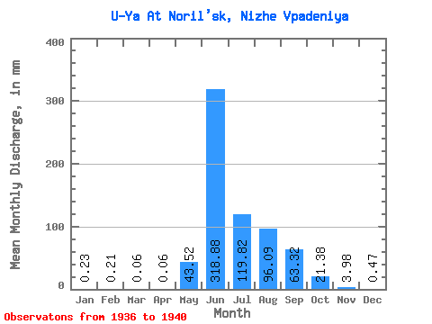
| Statistic | Jan | Feb | Mar | Apr | May | Jun | Jul | Aug | Sep | Oct | Nov | Dec | Annual |
|---|---|---|---|---|---|---|---|---|---|---|---|---|---|
| Mean | 0.22 | 0.20 | 0.07 | 0.07 | 43.53 | 318.88 | 119.81 | 96.08 | 63.32 | 21.38 | 3.97 | 0.47 | 673.27 |
| Standard Deviation | 0.28 | 0.26 | 0.15 | 0.14 | 55.95 | 59.41 | 51.79 | 47.00 | 30.18 | 7.64 | 4.17 | 0.49 | 156.32 |
| Min | 0.00 | 0.00 | 0.00 | 0.00 | 0.29 | 276.82 | 79.87 | 45.22 | 27.28 | 11.75 | 1.36 | 0.00 | 517.58 |
| Max | 0.59 | 0.54 | 0.29 | 0.28 | 122.74 | 405.85 | 193.80 | 167.38 | 90.95 | 29.95 | 11.37 | 1.18 | 882.43 |
| Coefficient of Variation | 1.28 | 1.28 | 2.00 | 2.00 | 1.28 | 0.19 | 0.43 | 0.49 | 0.48 | 0.36 | 1.05 | 1.05 | 0.23 |
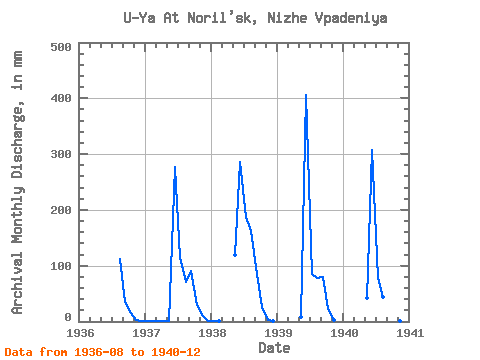
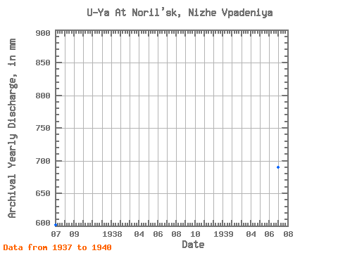
| Year | Jan | Feb | Mar | Apr | May | Jun | Jul | Aug | Sep | Oct | Nov | Dec | Annual | 1936 | 115.11 | 34.10 | 15.27 | 2.27 | 0.59 | 1937 | 0.29 | 0.27 | 0.29 | 0.28 | 0.29 | 276.82 | 116.87 | 72.82 | 90.95 | 29.95 | 11.37 | 0.59 | 602.42 | 1938 | 0.59 | 0.54 | 0.00 | 0.00 | 122.74 | 285.35 | 193.80 | 167.38 | 85.26 | 26.43 | 2.84 | 1.18 | 882.43 | 1939 | 0.00 | 0.00 | 0.00 | 0.00 | 8.22 | 405.85 | 88.68 | 79.87 | 79.01 | 23.49 | 1.99 | 0.00 | 690.66 | 1940 | 0.00 | 0.00 | 0.00 | 0.00 | 42.87 | 307.52 | 79.87 | 45.22 | 27.28 | 11.75 | 1.36 | 0.00 | 517.58 |
|---|
 Return to R-Arctic Net Home Page