|
|
|||||||||||||||||
| Point ID: 8388 | Downloads | Plots | Site Data | Code: 9477 |
|
|
|||||||||||||||||
| Download | |
|---|---|
| Site Descriptor Information | Site Time Series Data |
| Link to all available data | |
|
|
| View: | Statistics | Time Series |
| Units: | mm |
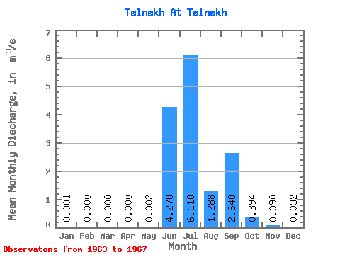
| Statistic | Jan | Feb | Mar | Apr | May | Jun | Jul | Aug | Sep | Oct | Nov | Dec | Annual |
|---|---|---|---|---|---|---|---|---|---|---|---|---|---|
| Mean | 0.00 | 0.00 | 0.00 | 0.00 | 0.00 | 4.28 | 6.11 | 1.29 | 2.64 | 0.39 | 0.09 | 0.03 | 1.24 |
| Standard Deviation | 0.00 | 0.00 | 0.00 | 0.00 | 0.00 | 2.70 | 1.95 | 0.99 | 1.54 | 0.38 | 0.03 | 0.02 | 0.16 |
| Min | 0.00 | 0.00 | 0.00 | 0.00 | 0.00 | 1.67 | 3.19 | 0.28 | 0.99 | 0.18 | 0.07 | 0.01 | 1.00 |
| Max | 0.00 | 0.00 | 0.00 | 0.00 | 0.01 | 7.52 | 8.31 | 2.91 | 5.00 | 1.07 | 0.14 | 0.07 | 1.44 |
| Coefficient of Variation | 1.37 | 1.77 | 0.63 | 0.32 | 0.77 | 0.58 | 0.96 | 0.33 | 0.71 | 0.13 |
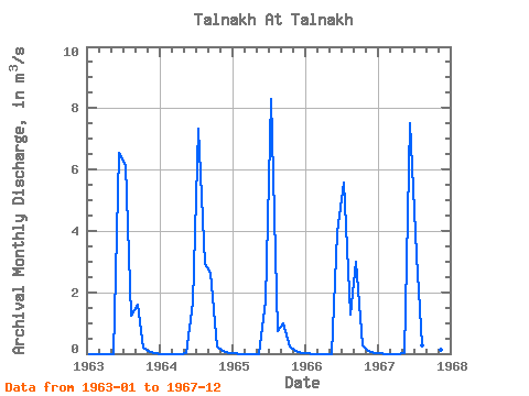
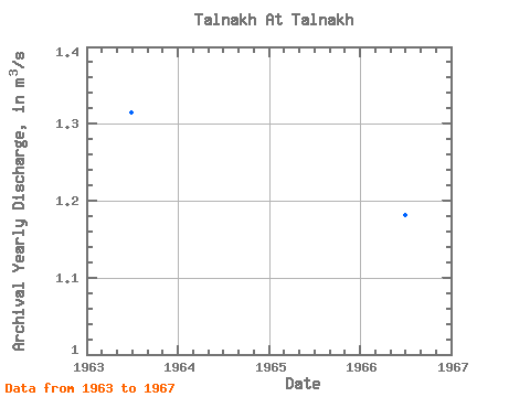
| Year | Jan | Feb | Mar | Apr | May | Jun | Jul | Aug | Sep | Oct | Nov | Dec | Annual | 1963 | 0.00 | 0.00 | 0.00 | 0.00 | 0.00 | 6.54 | 6.15 | 1.24 | 1.59 | 0.18 | 0.07 | 0.01 | 1.31 | 1964 | 0.00 | 0.00 | 0.00 | 0.00 | 0.00 | 1.67 | 7.33 | 2.91 | 2.63 | 0.22 | 0.09 | 0.03 | 1.24 | 1965 | 0.00 | 0.00 | 0.00 | 0.00 | 0.00 | 1.70 | 8.31 | 0.74 | 0.99 | 0.23 | 0.07 | 0.02 | 1.00 | 1966 | 0.00 | 0.00 | 0.00 | 0.00 | 0.00 | 3.96 | 5.57 | 1.27 | 2.99 | 0.27 | 0.08 | 0.03 | 1.18 | 1967 | 0.00 | 0.00 | 0.00 | 0.00 | 0.01 | 7.52 | 3.19 | 0.28 | 5.00 | 1.07 | 0.14 | 0.07 | 1.44 |
|---|
 Return to R-Arctic Net Home Page