|
|
|||||||||||||||||
| Point ID: 8388 | Downloads | Plots | Site Data | Code: 9477 |
|
|
|||||||||||||||||
| Download | |
|---|---|
| Site Descriptor Information | Site Time Series Data |
| Link to all available data | |
|
|
| View: | Statistics | Time Series |
| Units: | m3/s |
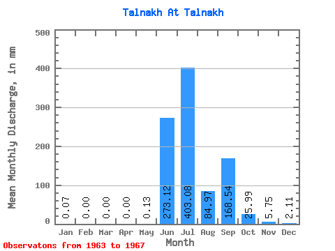
| Statistic | Jan | Feb | Mar | Apr | May | Jun | Jul | Aug | Sep | Oct | Nov | Dec | Annual |
|---|---|---|---|---|---|---|---|---|---|---|---|---|---|
| Mean | 0.08 | 0.00 | 0.00 | 0.00 | 0.14 | 273.12 | 403.02 | 84.96 | 168.54 | 25.99 | 5.76 | 2.08 | 961.00 |
| Standard Deviation | 0.11 | 0.00 | 0.00 | 0.00 | 0.26 | 172.42 | 128.36 | 65.55 | 98.48 | 25.02 | 1.88 | 1.48 | 125.39 |
| Min | 0.00 | 0.00 | 0.00 | 0.00 | 0.00 | 106.62 | 210.41 | 18.47 | 63.20 | 11.87 | 4.21 | 0.79 | 781.49 |
| Max | 0.26 | 0.00 | 0.00 | 0.00 | 0.59 | 480.10 | 548.13 | 191.94 | 319.21 | 70.58 | 8.94 | 4.55 | 1119.31 |
| Coefficient of Variation | 1.37 | 1.77 | 0.63 | 0.32 | 0.77 | 0.58 | 0.96 | 0.33 | 0.71 | 0.13 |
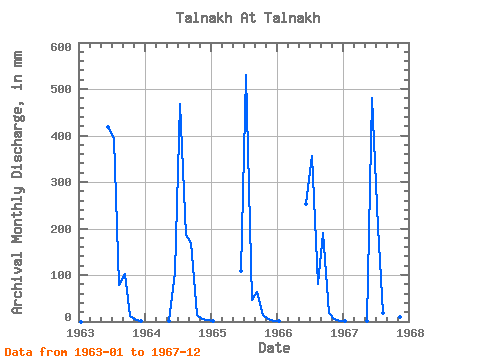
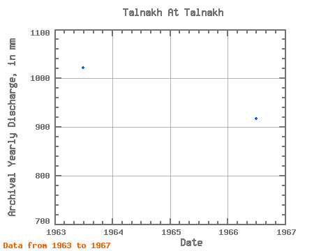
| Year | Jan | Feb | Mar | Apr | May | Jun | Jul | Aug | Sep | Oct | Nov | Dec | Annual | 1963 | 0.00 | 0.00 | 0.00 | 0.00 | 0.00 | 417.53 | 405.66 | 81.79 | 101.51 | 11.87 | 4.21 | 0.79 | 1022.07 | 1964 | 0.00 | 0.00 | 0.00 | 0.00 | 0.13 | 106.62 | 483.49 | 191.94 | 167.91 | 14.51 | 5.81 | 2.24 | 964.36 | 1965 | 0.26 | 0.00 | 0.00 | 0.00 | 0.00 | 108.53 | 548.13 | 48.81 | 63.20 | 15.17 | 4.60 | 1.19 | 781.49 | 1966 | 0.07 | 0.00 | 0.00 | 0.00 | 0.00 | 252.82 | 367.40 | 83.77 | 190.89 | 17.81 | 5.24 | 1.65 | 917.78 | 1967 | 0.07 | 0.00 | 0.00 | 0.00 | 0.59 | 480.10 | 210.41 | 18.47 | 319.21 | 70.58 | 8.94 | 4.55 | 1119.31 |
|---|
 Return to R-Arctic Net Home Page