|
|
|||||||||||||||||
| Point ID: 8384 | Downloads | Plots | Site Data | Code: 9470 |
|
|
|||||||||||||||||
| Download | |
|---|---|
| Site Descriptor Information | Site Time Series Data |
| Link to all available data | |
|
|
| View: | Statistics | Time Series |
| Units: | mm |
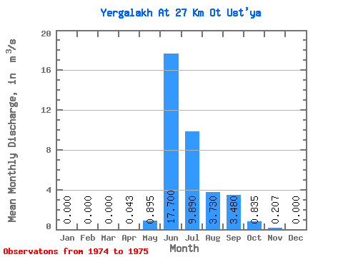
| Statistic | Jan | Feb | Mar | Apr | May | Jun | Jul | Aug | Sep | Oct | Nov | Dec | Annual |
|---|---|---|---|---|---|---|---|---|---|---|---|---|---|
| Mean | 0.00 | 0.00 | 0.00 | 0.04 | 0.90 | 17.70 | 9.89 | 3.73 | 3.48 | 0.83 | 0.21 | 0.00 | 3.06 |
| Standard Deviation | 0.00 | 0.00 | 0.00 | 0.06 | 0.63 | 8.91 | 4.12 | 0.62 | 1.19 | 0.11 | 0.24 | 0.00 | 0.34 |
| Min | 0.00 | 0.00 | 0.00 | 0.00 | 0.45 | 11.40 | 6.98 | 3.29 | 2.64 | 0.76 | 0.04 | 0.00 | 2.83 |
| Max | 0.00 | 0.00 | 0.00 | 0.09 | 1.34 | 24.00 | 12.80 | 4.17 | 4.32 | 0.91 | 0.38 | 0.00 | 3.30 |
| Coefficient of Variation | 1.41 | 0.70 | 0.50 | 0.42 | 0.17 | 0.34 | 0.13 | 1.18 | 0.11 |
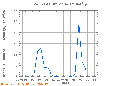
| Year | Jan | Feb | Mar | Apr | May | Jun | Jul | Aug | Sep | Oct | Nov | Dec | Annual | 1974 | 0.00 | 0.00 | 0.00 | 0.00 | 0.45 | 11.40 | 12.80 | 4.17 | 4.32 | 0.76 | 0.04 | 0.00 | 2.83 | 1975 | 0.00 | 0.00 | 0.00 | 0.09 | 1.34 | 24.00 | 6.98 | 3.29 | 2.64 | 0.91 | 0.38 | 0.00 | 3.30 |
|---|
 Return to R-Arctic Net Home Page