|
|
|||||||||||||||||
| Point ID: 8384 | Downloads | Plots | Site Data | Code: 9470 |
|
|
|||||||||||||||||
| Download | |
|---|---|
| Site Descriptor Information | Site Time Series Data |
| Link to all available data | |
|
|
| View: | Statistics | Time Series |
| Units: | m3/s |
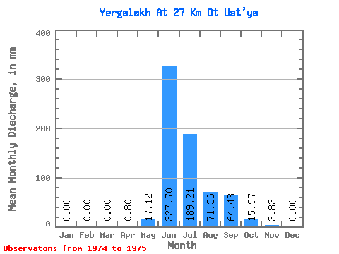
| Statistic | Jan | Feb | Mar | Apr | May | Jun | Jul | Aug | Sep | Oct | Nov | Dec | Annual |
|---|---|---|---|---|---|---|---|---|---|---|---|---|---|
| Mean | 0.00 | 0.00 | 0.00 | 0.81 | 17.12 | 327.70 | 189.18 | 71.35 | 64.43 | 15.97 | 3.84 | 0.00 | 690.96 |
| Standard Deviation | 0.00 | 0.00 | 0.00 | 1.14 | 12.04 | 164.95 | 78.72 | 11.90 | 21.99 | 2.03 | 4.52 | 0.00 | 75.61 |
| Min | 0.00 | 0.00 | 0.00 | 0.00 | 8.61 | 211.06 | 133.52 | 62.93 | 48.88 | 14.54 | 0.65 | 0.00 | 637.49 |
| Max | 0.00 | 0.00 | 0.00 | 1.61 | 25.63 | 444.34 | 244.85 | 79.77 | 79.98 | 17.41 | 7.04 | 0.00 | 744.42 |
| Coefficient of Variation | 1.41 | 0.70 | 0.50 | 0.42 | 0.17 | 0.34 | 0.13 | 1.18 | 0.11 |
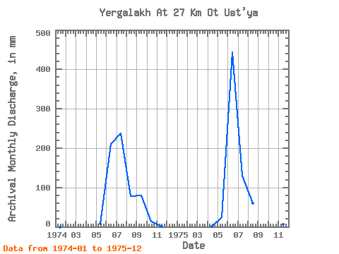
| Year | Jan | Feb | Mar | Apr | May | Jun | Jul | Aug | Sep | Oct | Nov | Dec | Annual | 1974 | 0.00 | 0.00 | 0.00 | 0.00 | 8.61 | 211.06 | 244.85 | 79.77 | 79.98 | 14.54 | 0.65 | 0.00 | 637.49 | 1975 | 0.00 | 0.00 | 0.00 | 1.61 | 25.63 | 444.34 | 133.52 | 62.93 | 48.88 | 17.41 | 7.04 | 0.00 | 744.42 |
|---|
 Return to R-Arctic Net Home Page