|
|
|||||||||||||||||
| Point ID: 8366 | Downloads | Plots | Site Data | Code: 9391 |
|
|
|||||||||||||||||
| Download | |
|---|---|
| Site Descriptor Information | Site Time Series Data |
| Link to all available data | |
|
|
| View: | Statistics | Time Series |
| Units: | mm |
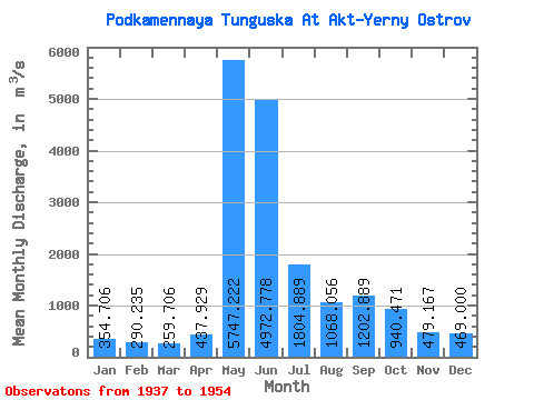
| Statistic | Jan | Feb | Mar | Apr | May | Jun | Jul | Aug | Sep | Oct | Nov | Dec | Annual |
|---|---|---|---|---|---|---|---|---|---|---|---|---|---|
| Mean | 354.71 | 290.24 | 259.71 | 437.93 | 5747.22 | 4972.78 | 1804.89 | 1068.06 | 1202.89 | 940.47 | 479.17 | 469.00 | 1651.26 |
| Standard Deviation | 103.01 | 74.95 | 69.52 | 351.27 | 2878.80 | 1550.12 | 616.22 | 319.61 | 381.51 | 304.18 | 171.77 | 148.80 | 159.36 |
| Min | 182.00 | 174.00 | 153.00 | 165.00 | 400.00 | 2610.00 | 938.00 | 551.00 | 611.00 | 418.00 | 110.00 | 215.00 | 1424.67 |
| Max | 635.00 | 495.00 | 437.00 | 1340.00 | 8840.00 | 8160.00 | 3060.00 | 1660.00 | 2060.00 | 1690.00 | 824.00 | 907.00 | 1949.00 |
| Coefficient of Variation | 0.29 | 0.26 | 0.27 | 0.80 | 0.50 | 0.31 | 0.34 | 0.30 | 0.32 | 0.32 | 0.36 | 0.32 | 0.10 |
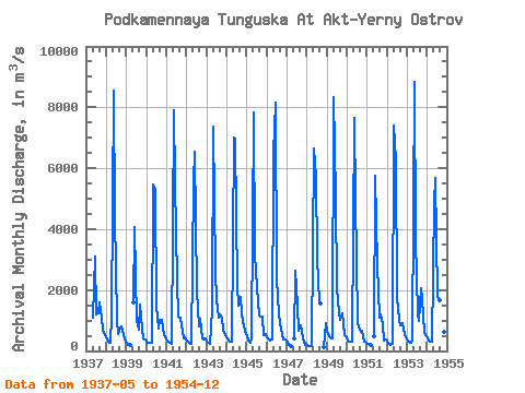
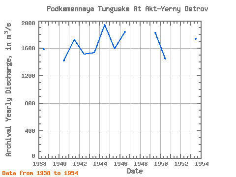
| Year | Jan | Feb | Mar | Apr | May | Jun | Jul | Aug | Sep | Oct | Nov | Dec | Annual | 1937 | 1100.00 | 3090.00 | 1210.00 | 1230.00 | 1580.00 | 1090.00 | 664.00 | 509.00 | 1938 | 379.00 | 311.00 | 262.00 | 1140.00 | 8540.00 | 4420.00 | 1020.00 | 551.00 | 762.00 | 810.00 | 513.00 | 365.00 | 1589.42 | 1939 | 266.00 | 207.00 | 194.00 | 1600.00 | 4070.00 | 1000.00 | 716.00 | 1540.00 | 751.00 | 409.00 | 382.00 | 1940 | 314.00 | 275.00 | 266.00 | 279.00 | 5450.00 | 5280.00 | 1480.00 | 744.00 | 1010.00 | 1030.00 | 505.00 | 463.00 | 1424.67 | 1941 | 347.00 | 290.00 | 257.00 | 223.00 | 7910.00 | 5540.00 | 2320.00 | 1140.00 | 1080.00 | 836.00 | 414.00 | 435.00 | 1732.67 | 1942 | 344.00 | 290.00 | 246.00 | 227.00 | 5530.00 | 6530.00 | 1970.00 | 822.00 | 1070.00 | 418.00 | 372.00 | 402.00 | 1518.42 | 1943 | 314.00 | 266.00 | 227.00 | 1340.00 | 7370.00 | 2610.00 | 1720.00 | 1100.00 | 1210.00 | 1100.00 | 656.00 | 524.00 | 1536.42 | 1944 | 401.00 | 331.00 | 299.00 | 305.00 | 6990.00 | 6930.00 | 2150.00 | 1500.00 | 1790.00 | 1200.00 | 824.00 | 668.00 | 1949.00 | 1945 | 475.00 | 330.00 | 274.00 | 436.00 | 7840.00 | 3160.00 | 2110.00 | 1180.00 | 1140.00 | 1130.00 | 529.00 | 553.00 | 1596.42 | 1946 | 437.00 | 366.00 | 357.00 | 385.00 | 6510.00 | 8160.00 | 2380.00 | 1200.00 | 931.00 | 562.00 | 394.00 | 393.00 | 1839.58 | 1947 | 287.00 | 210.00 | 173.00 | 400.00 | 2620.00 | 1480.00 | 661.00 | 843.00 | 624.00 | 253.00 | 215.00 | 1948 | 182.00 | 174.00 | 153.00 | 165.00 | 6650.00 | 5730.00 | 3060.00 | 1590.00 | 1560.00 | 110.00 | 907.00 | 1949 | 635.00 | 495.00 | 437.00 | 425.00 | 8320.00 | 5020.00 | 2070.00 | 1270.00 | 1020.00 | 1240.00 | 503.00 | 496.00 | 1827.58 | 1950 | 342.00 | 290.00 | 290.00 | 291.00 | 7660.00 | 4980.00 | 938.00 | 762.00 | 611.00 | 666.00 | 306.00 | 304.00 | 1453.33 | 1951 | 248.00 | 217.00 | 189.00 | 500.00 | 5770.00 | 2820.00 | 1080.00 | 1200.00 | 877.00 | 352.00 | 385.00 | 1952 | 307.00 | 244.00 | 214.00 | 235.00 | 7400.00 | 6240.00 | 1760.00 | 1030.00 | 855.00 | 924.00 | 572.00 | 432.00 | 1684.42 | 1953 | 318.00 | 290.00 | 273.00 | 387.00 | 8840.00 | 3690.00 | 1210.00 | 989.00 | 2060.00 | 1690.00 | 625.00 | 503.00 | 1739.58 | 1954 | 434.00 | 348.00 | 304.00 | 293.00 | 4840.00 | 5670.00 | 1790.00 | 1660.00 | 1390.00 | 1040.00 | 624.00 | 506.00 | 1574.92 |
|---|
 Return to R-Arctic Net Home Page