|
|
|||||||||||||||||
| Point ID: 8297 | Downloads | Plots | Site Data | Code: 9157 |
|
|
|||||||||||||||||
| Download | |
|---|---|
| Site Descriptor Information | Site Time Series Data |
| Link to all available data | |
|
|
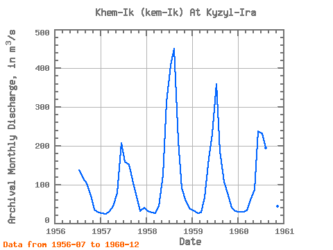
| View: | Statistics | Time Series |
| Units: | mm |
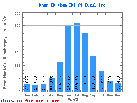
| Statistic | Jan | Feb | Mar | Apr | May | Jun | Jul | Aug | Sep | Oct | Nov | Dec | Annual |
|---|---|---|---|---|---|---|---|---|---|---|---|---|---|
| Mean | 29.88 | 27.05 | 29.70 | 53.83 | 114.35 | 246.75 | 259.20 | 220.00 | 133.80 | 77.62 | 41.30 | 33.46 | 111.33 |
| Standard Deviation | 3.39 | 1.91 | 3.66 | 11.36 | 40.86 | 45.99 | 120.43 | 132.84 | 45.44 | 9.26 | 9.26 | 5.59 | 29.95 |
| Min | 25.20 | 24.80 | 25.10 | 44.10 | 78.60 | 207.00 | 137.00 | 116.00 | 103.00 | 67.50 | 31.60 | 26.90 | 81.22 |
| Max | 32.70 | 29.40 | 33.20 | 66.80 | 168.00 | 313.00 | 408.00 | 451.00 | 212.00 | 91.30 | 55.70 | 40.40 | 151.80 |
| Coefficient of Variation | 0.11 | 0.07 | 0.12 | 0.21 | 0.36 | 0.19 | 0.47 | 0.60 | 0.34 | 0.12 | 0.22 | 0.17 | 0.27 |
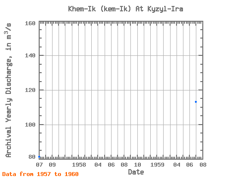
| Year | Jan | Feb | Mar | Apr | May | Jun | Jul | Aug | Sep | Oct | Nov | Dec | Annual | 1956 | 137.00 | 116.00 | 103.00 | 70.80 | 35.30 | 26.90 | 1957 | 25.20 | 24.80 | 32.00 | 44.50 | 78.60 | 207.00 | 159.00 | 152.00 | 112.00 | 67.50 | 31.60 | 40.40 | 81.22 | 1958 | 32.00 | 27.40 | 25.10 | 44.10 | 124.00 | 313.00 | 408.00 | 451.00 | 212.00 | 91.30 | 55.70 | 38.00 | 151.80 | 1959 | 32.70 | 26.60 | 28.50 | 66.80 | 168.00 | 230.00 | 360.00 | 186.00 | 107.00 | 78.30 | 40.40 | 31.80 | 113.01 | 1960 | 29.60 | 29.40 | 33.20 | 59.90 | 86.80 | 237.00 | 232.00 | 195.00 | 135.00 | 80.20 | 43.50 | 30.20 | 99.32 |
|---|
 Return to R-Arctic Net Home Page