|
|
|||||||||||||||||
| Point ID: 8297 | Downloads | Plots | Site Data | Code: 9157 |
|
|
|||||||||||||||||
| Download | |
|---|---|
| Site Descriptor Information | Site Time Series Data |
| Link to all available data | |
|
|
| View: | Statistics | Time Series |
| Units: | m3/s |
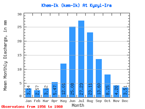
| Statistic | Jan | Feb | Mar | Apr | May | Jun | Jul | Aug | Sep | Oct | Nov | Dec | Annual |
|---|---|---|---|---|---|---|---|---|---|---|---|---|---|
| Mean | 3.14 | 2.59 | 3.12 | 5.47 | 12.01 | 25.08 | 27.22 | 23.10 | 13.60 | 8.15 | 4.20 | 3.51 | 137.79 |
| Standard Deviation | 0.36 | 0.18 | 0.38 | 1.15 | 4.29 | 4.67 | 12.65 | 13.95 | 4.62 | 0.97 | 0.94 | 0.59 | 37.07 |
| Min | 2.65 | 2.37 | 2.64 | 4.48 | 8.26 | 21.04 | 14.39 | 12.18 | 10.47 | 7.09 | 3.21 | 2.83 | 100.52 |
| Max | 3.43 | 2.81 | 3.49 | 6.79 | 17.64 | 31.82 | 42.85 | 47.36 | 21.55 | 9.59 | 5.66 | 4.24 | 187.88 |
| Coefficient of Variation | 0.11 | 0.07 | 0.12 | 0.21 | 0.36 | 0.19 | 0.47 | 0.60 | 0.34 | 0.12 | 0.22 | 0.17 | 0.27 |
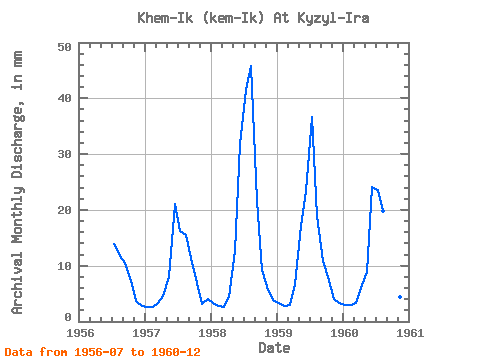
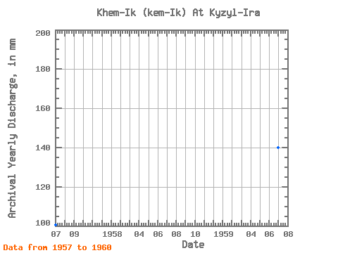
| Year | Jan | Feb | Mar | Apr | May | Jun | Jul | Aug | Sep | Oct | Nov | Dec | Annual | 1956 | 14.39 | 12.18 | 10.47 | 7.43 | 3.59 | 2.83 | 1957 | 2.65 | 2.37 | 3.36 | 4.52 | 8.26 | 21.04 | 16.70 | 15.96 | 11.38 | 7.09 | 3.21 | 4.24 | 100.52 | 1958 | 3.36 | 2.62 | 2.64 | 4.48 | 13.02 | 31.82 | 42.85 | 47.36 | 21.55 | 9.59 | 5.66 | 3.99 | 187.88 | 1959 | 3.43 | 2.54 | 2.99 | 6.79 | 17.64 | 23.38 | 37.81 | 19.53 | 10.88 | 8.22 | 4.11 | 3.34 | 139.86 | 1960 | 3.11 | 2.81 | 3.49 | 6.09 | 9.12 | 24.09 | 24.36 | 20.48 | 13.72 | 8.42 | 4.42 | 3.17 | 122.92 |
|---|
 Return to R-Arctic Net Home Page