|
|
|||||||||||||||||
| Point ID: 8291 | Downloads | Plots | Site Data | Code: 9131 |
|
|
|||||||||||||||||
| Download | |
|---|---|
| Site Descriptor Information | Site Time Series Data |
| Link to all available data | |
|
|
| View: | Statistics | Time Series |
| Units: | mm |
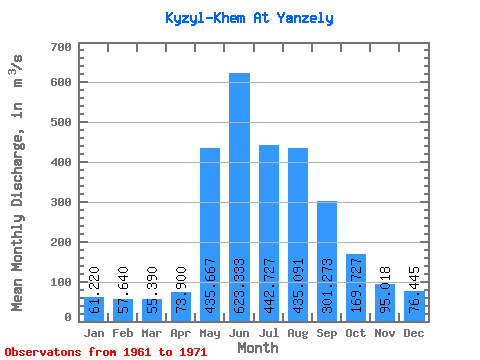
| Statistic | Jan | Feb | Mar | Apr | May | Jun | Jul | Aug | Sep | Oct | Nov | Dec | Annual |
|---|---|---|---|---|---|---|---|---|---|---|---|---|---|
| Mean | 61.22 | 57.64 | 55.39 | 73.90 | 435.67 | 623.33 | 442.73 | 435.09 | 301.27 | 169.73 | 95.02 | 76.44 | 238.73 |
| Standard Deviation | 8.51 | 9.89 | 8.78 | 10.06 | 108.28 | 251.88 | 144.82 | 139.13 | 45.22 | 30.77 | 16.00 | 16.23 | 45.10 |
| Min | 52.30 | 49.20 | 42.80 | 58.30 | 252.00 | 361.00 | 256.00 | 220.00 | 249.00 | 128.00 | 61.00 | 55.90 | 182.29 |
| Max | 77.60 | 81.50 | 75.50 | 87.20 | 591.00 | 1230.00 | 703.00 | 612.00 | 383.00 | 230.00 | 118.00 | 117.00 | 333.89 |
| Coefficient of Variation | 0.14 | 0.17 | 0.16 | 0.14 | 0.25 | 0.40 | 0.33 | 0.32 | 0.15 | 0.18 | 0.17 | 0.21 | 0.19 |
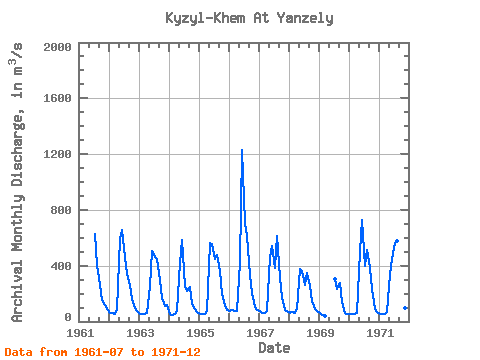
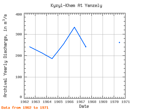
| Year | Jan | Feb | Mar | Apr | May | Jun | Jul | Aug | Sep | Oct | Nov | Dec | Annual | 1961 | 627.00 | 402.00 | 261.00 | 152.00 | 118.00 | 86.70 | 1962 | 64.00 | 60.30 | 55.00 | 87.20 | 591.00 | 654.00 | 459.00 | 343.00 | 259.00 | 163.00 | 97.60 | 72.30 | 242.12 | 1963 | 56.90 | 53.20 | 52.50 | 60.70 | 252.00 | 504.00 | 461.00 | 449.00 | 298.00 | 169.00 | 109.00 | 117.00 | 215.19 | 1964 | 52.30 | 49.20 | 50.40 | 73.60 | 418.00 | 587.00 | 256.00 | 220.00 | 249.00 | 128.00 | 87.20 | 65.30 | 186.33 | 1965 | 56.70 | 52.80 | 52.30 | 71.80 | 565.00 | 557.00 | 451.00 | 474.00 | 359.00 | 200.00 | 110.00 | 79.40 | 252.42 | 1966 | 77.60 | 81.50 | 75.50 | 77.50 | 417.00 | 1230.00 | 703.00 | 612.00 | 336.00 | 206.00 | 107.00 | 83.60 | 333.89 | 1967 | 73.50 | 58.70 | 59.40 | 77.60 | 460.00 | 539.00 | 380.00 | 612.00 | 317.00 | 168.00 | 81.80 | 72.60 | 241.63 | 1968 | 61.70 | 66.10 | 62.10 | 87.20 | 374.00 | 361.00 | 261.00 | 348.00 | 257.00 | 144.00 | 88.10 | 77.30 | 182.29 | 1969 | 61.50 | 50.00 | 42.80 | 307.00 | 236.00 | 277.00 | 141.00 | 61.00 | 55.90 | 1970 | 54.90 | 51.30 | 50.80 | 58.30 | 505.00 | 731.00 | 399.00 | 513.00 | 383.00 | 230.00 | 90.30 | 65.80 | 261.03 | 1971 | 53.10 | 53.30 | 53.10 | 71.20 | 339.00 | 447.00 | 566.00 | 577.00 | 318.00 | 166.00 | 95.20 | 65.00 | 233.66 |
|---|
 Return to R-Arctic Net Home Page