|
|
|||||||||||||||||
| Point ID: 8283 | Downloads | Plots | Site Data | Code: 9019 |
|
|
|||||||||||||||||
| Download | |
|---|---|
| Site Descriptor Information | Site Time Series Data |
| Link to all available data | |
| View: | Time Series | All |
| Units: | m3/s |
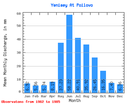
| Statistic | Jan | Feb | Mar | Apr | May | Jun | Jul | Aug | Sep | Oct | Nov | Dec | Annual |
|---|---|---|---|---|---|---|---|---|---|---|---|---|---|
| Mean | 6.92 | 5.60 | 5.74 | 8.19 | 37.22 | 58.22 | 40.90 | 35.91 | 26.45 | 16.35 | 7.40 | 6.36 | 254.95 |
| Standard Deviation | 2.83 | 2.61 | 2.68 | 2.07 | 12.38 | 20.10 | 11.74 | 9.32 | 5.86 | 4.73 | 2.23 | 2.64 | 40.66 |
| Min | 4.38 | 3.19 | 3.68 | 5.56 | 11.17 | 27.07 | 19.97 | 20.42 | 17.61 | 6.72 | 4.15 | 1.18 | 196.29 |
| Max | 12.87 | 10.80 | 12.46 | 12.77 | 60.66 | 114.56 | 62.73 | 54.30 | 37.09 | 27.96 | 13.49 | 13.88 | 348.06 |
| Coefficient of Variation | 0.41 | 0.47 | 0.47 | 0.25 | 0.33 | 0.34 | 0.29 | 0.26 | 0.22 | 0.29 | 0.30 | 0.41 | 0.16 |
 Return to R-Arctic Net Home Page