|
|
|||||||||||||||||
| Point ID: 8283 | Downloads | Plots | Site Data | Code: 9019 |
|
|
|||||||||||||||||
| Download | |
|---|---|
| Site Descriptor Information | Site Time Series Data |
| Link to all available data | |
| View: | Time Series | All |
| Units: | mm |
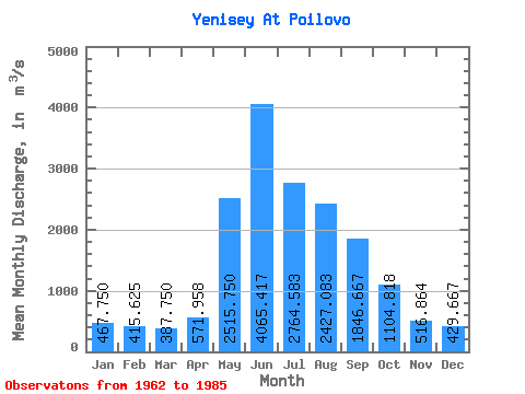
| Statistic | Jan | Feb | Mar | Apr | May | Jun | Jul | Aug | Sep | Oct | Nov | Dec | Annual |
|---|---|---|---|---|---|---|---|---|---|---|---|---|---|
| Mean | 467.75 | 415.62 | 387.75 | 571.96 | 2515.75 | 4065.42 | 2764.58 | 2427.08 | 1846.67 | 1104.82 | 516.86 | 429.67 | 1462.16 |
| Standard Deviation | 191.09 | 193.73 | 180.96 | 144.48 | 837.01 | 1403.32 | 793.70 | 629.68 | 408.95 | 319.61 | 155.90 | 178.41 | 233.21 |
| Min | 296.00 | 237.00 | 249.00 | 388.00 | 755.00 | 1890.00 | 1350.00 | 1380.00 | 1230.00 | 454.00 | 290.00 | 80.00 | 1125.75 |
| Max | 870.00 | 801.00 | 842.00 | 892.00 | 4100.00 | 8000.00 | 4240.00 | 3670.00 | 2590.00 | 1890.00 | 942.00 | 938.00 | 1996.17 |
| Coefficient of Variation | 0.41 | 0.47 | 0.47 | 0.25 | 0.33 | 0.34 | 0.29 | 0.26 | 0.22 | 0.29 | 0.30 | 0.41 | 0.16 |
 Return to R-Arctic Net Home Page