|
|
|||||||||||||||||
| Point ID: 8283 | Downloads | Plots | Site Data | Code: 9019 |
|
|
|||||||||||||||||
| Download | |
|---|---|
| Site Descriptor Information | Site Time Series Data |
| Link to all available data | |
|
|
| View: | Statistics | Time Series |
| Units: | mm |
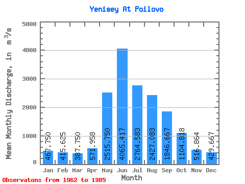
| Statistic | Jan | Feb | Mar | Apr | May | Jun | Jul | Aug | Sep | Oct | Nov | Dec | Annual |
|---|---|---|---|---|---|---|---|---|---|---|---|---|---|
| Mean | 467.75 | 415.62 | 387.75 | 571.96 | 2515.75 | 4065.42 | 2764.58 | 2427.08 | 1846.67 | 1104.82 | 516.86 | 429.67 | 1462.16 |
| Standard Deviation | 191.09 | 193.73 | 180.96 | 144.48 | 837.01 | 1403.32 | 793.70 | 629.68 | 408.95 | 319.61 | 155.90 | 178.41 | 233.21 |
| Min | 296.00 | 237.00 | 249.00 | 388.00 | 755.00 | 1890.00 | 1350.00 | 1380.00 | 1230.00 | 454.00 | 290.00 | 80.00 | 1125.75 |
| Max | 870.00 | 801.00 | 842.00 | 892.00 | 4100.00 | 8000.00 | 4240.00 | 3670.00 | 2590.00 | 1890.00 | 942.00 | 938.00 | 1996.17 |
| Coefficient of Variation | 0.41 | 0.47 | 0.47 | 0.25 | 0.33 | 0.34 | 0.29 | 0.26 | 0.22 | 0.29 | 0.30 | 0.41 | 0.16 |
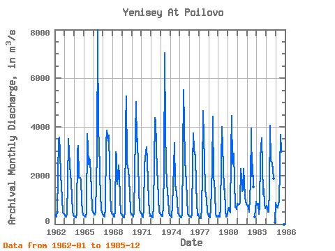
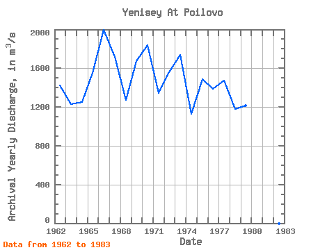
| Year | Jan | Feb | Mar | Apr | May | Jun | Jul | Aug | Sep | Oct | Nov | Dec | Annual | 1962 | 389.00 | 317.00 | 314.00 | 528.00 | 3490.00 | 3580.00 | 2960.00 | 2000.00 | 1600.00 | 1060.00 | 463.00 | 405.00 | 1425.50 | 1963 | 349.00 | 310.00 | 308.00 | 407.00 | 1720.00 | 3510.00 | 2440.00 | 1990.00 | 1760.00 | 1090.00 | 534.00 | 371.00 | 1232.42 | 1964 | 339.00 | 275.00 | 266.00 | 388.00 | 2990.00 | 3230.00 | 1920.00 | 1920.00 | 1810.00 | 989.00 | 500.00 | 381.00 | 1250.67 | 1965 | 369.00 | 322.00 | 310.00 | 469.00 | 3710.00 | 3140.00 | 2440.00 | 2710.00 | 2590.00 | 1450.00 | 585.00 | 507.00 | 1550.17 | 1966 | 439.00 | 385.00 | 383.00 | 506.00 | 2900.00 | 8000.00 | 3590.00 | 3540.00 | 2000.00 | 1220.00 | 574.00 | 417.00 | 1996.17 | 1967 | 356.00 | 317.00 | 315.00 | 653.00 | 3280.00 | 3870.00 | 3430.00 | 3670.00 | 2350.00 | 1320.00 | 554.00 | 451.00 | 1713.83 | 1968 | 407.00 | 304.00 | 297.00 | 536.00 | 2960.00 | 2790.00 | 1640.00 | 2430.00 | 1980.00 | 1100.00 | 452.00 | 412.00 | 1275.67 | 1969 | 351.00 | 296.00 | 261.00 | 503.00 | 4100.00 | 5260.00 | 2550.00 | 2300.00 | 2290.00 | 1310.00 | 508.00 | 396.00 | 1677.08 | 1970 | 405.00 | 352.00 | 300.00 | 501.00 | 3670.00 | 5020.00 | 3400.00 | 3520.00 | 2340.00 | 1550.00 | 548.00 | 444.00 | 1837.50 | 1971 | 396.00 | 318.00 | 271.00 | 615.00 | 2400.00 | 2750.00 | 3170.00 | 2620.00 | 1730.00 | 1030.00 | 508.00 | 328.00 | 1344.67 | 1972 | 359.00 | 281.00 | 276.00 | 734.00 | 2440.00 | 4360.00 | 4240.00 | 2200.00 | 1790.00 | 1050.00 | 515.00 | 439.00 | 1557.00 | 1973 | 413.00 | 358.00 | 318.00 | 723.00 | 2160.00 | 7040.00 | 3860.00 | 2430.00 | 1690.00 | 1020.00 | 514.00 | 351.00 | 1739.75 | 1974 | 345.00 | 316.00 | 275.00 | 791.00 | 2340.00 | 3350.00 | 1620.00 | 1460.00 | 1280.00 | 945.00 | 458.00 | 329.00 | 1125.75 | 1975 | 317.00 | 272.00 | 273.00 | 411.00 | 2710.00 | 5510.00 | 2680.00 | 2100.00 | 1770.00 | 1040.00 | 419.00 | 372.00 | 1489.50 | 1976 | 335.00 | 292.00 | 282.00 | 412.00 | 2520.00 | 3730.00 | 3050.00 | 2790.00 | 1580.00 | 915.00 | 369.00 | 406.00 | 1390.08 | 1977 | 296.00 | 237.00 | 249.00 | 632.00 | 2110.00 | 4660.00 | 3510.00 | 2660.00 | 1430.00 | 1030.00 | 528.00 | 378.00 | 1476.67 | 1978 | 326.00 | 286.00 | 283.00 | 606.00 | 2320.00 | 4430.00 | 1850.00 | 1770.00 | 1250.00 | 454.00 | 293.00 | 308.00 | 1181.33 | 1979 | 361.00 | 311.00 | 298.00 | 645.00 | 2560.00 | 3990.00 | 2360.00 | 1430.00 | 1460.00 | 565.00 | 293.00 | 332.00 | 1217.08 | 1980 | 613.00 | 685.00 | 527.00 | 474.00 | 2900.00 | 4450.00 | 2490.00 | 2920.00 | 1780.00 | 698.00 | 714.00 | 606.00 | 1571.42 | 1981 | 848.00 | 786.00 | 810.00 | 892.00 | 2270.00 | 1890.00 | 1350.00 | 1380.00 | 2280.00 | 1120.00 | 942.00 | 815.00 | 1281.92 | 1982 | 781.00 | 740.00 | 665.00 | 515.00 | 1720.00 | 3930.00 | 1970.00 | 2450.00 | 1520.00 | 290.00 | 938.00 | 1983 | 796.00 | 801.00 | 842.00 | 414.00 | 755.00 | 2740.00 | 3540.00 | 2420.00 | 1230.00 | 1460.00 | 810.00 | 646.00 | 1371.17 | 1984 | 766.00 | 671.00 | 511.00 | 516.00 | 1460.00 | 4060.00 | 2600.00 | 2550.00 | 2220.00 | 1890.00 | 80.00 | 1985 | 870.00 | 743.00 | 672.00 | 856.00 | 893.00 | 2280.00 | 3690.00 | 2990.00 | 2590.00 | 200.00 |
|---|
 Return to R-Arctic Net Home Page