|
|
|||||||||||||||||
| Point ID: 8281 | Downloads | Plots | Site Data | Code: 9004 |
|
|
|||||||||||||||||
| Download | |
|---|---|
| Site Descriptor Information | Site Time Series Data |
| Link to all available data | |
| View: | Time Series | All |
| Units: | m3/s |
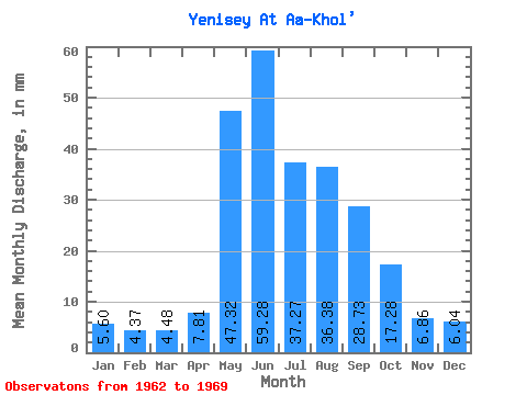
| Statistic | Jan | Feb | Mar | Apr | May | Jun | Jul | Aug | Sep | Oct | Nov | Dec | Annual |
|---|---|---|---|---|---|---|---|---|---|---|---|---|---|
| Mean | 5.60 | 4.41 | 4.48 | 7.81 | 47.31 | 59.28 | 37.27 | 36.38 | 28.73 | 17.28 | 6.86 | 6.04 | 260.53 |
| Standard Deviation | 0.67 | 0.67 | 0.75 | 3.15 | 9.99 | 20.76 | 11.68 | 12.05 | 4.27 | 2.53 | 1.12 | 0.49 | 45.36 |
| Min | 4.60 | 3.56 | 3.56 | 5.73 | 27.20 | 39.08 | 22.80 | 23.85 | 23.09 | 14.39 | 5.06 | 5.42 | 204.48 |
| Max | 6.32 | 5.49 | 5.42 | 15.39 | 58.16 | 105.50 | 57.33 | 57.33 | 35.44 | 21.34 | 8.89 | 6.90 | 349.48 |
| Coefficient of Variation | 0.12 | 0.15 | 0.17 | 0.40 | 0.21 | 0.35 | 0.31 | 0.33 | 0.15 | 0.15 | 0.16 | 0.08 | 0.17 |
 Return to R-Arctic Net Home Page