|
|
|||||||||||||||||
| Point ID: 8281 | Downloads | Plots | Site Data | Code: 9004 |
|
|
|||||||||||||||||
| Download | |
|---|---|
| Site Descriptor Information | Site Time Series Data |
| Link to all available data | |
| View: | Time Series | All |
| Units: | mm |
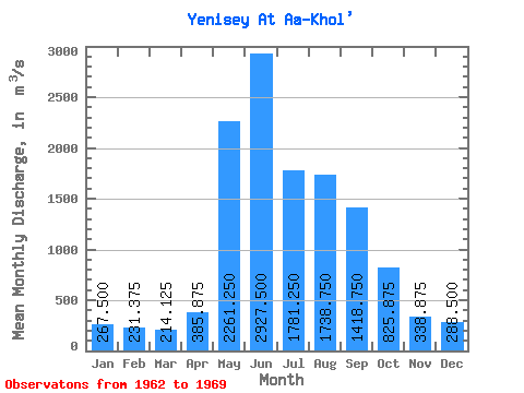
| Statistic | Jan | Feb | Mar | Apr | May | Jun | Jul | Aug | Sep | Oct | Nov | Dec | Annual |
|---|---|---|---|---|---|---|---|---|---|---|---|---|---|
| Mean | 267.50 | 231.38 | 214.12 | 385.88 | 2261.25 | 2927.50 | 1781.25 | 1738.75 | 1418.75 | 825.88 | 338.88 | 288.50 | 1056.63 |
| Standard Deviation | 31.78 | 34.91 | 35.83 | 155.28 | 477.36 | 1024.97 | 558.27 | 575.91 | 210.81 | 120.99 | 55.38 | 23.47 | 183.97 |
| Min | 220.00 | 187.00 | 170.00 | 283.00 | 1300.00 | 1930.00 | 1090.00 | 1140.00 | 1140.00 | 688.00 | 250.00 | 259.00 | 829.33 |
| Max | 302.00 | 288.00 | 259.00 | 760.00 | 2780.00 | 5210.00 | 2740.00 | 2740.00 | 1750.00 | 1020.00 | 439.00 | 330.00 | 1417.42 |
| Coefficient of Variation | 0.12 | 0.15 | 0.17 | 0.40 | 0.21 | 0.35 | 0.31 | 0.33 | 0.15 | 0.15 | 0.16 | 0.08 | 0.17 |
 Return to R-Arctic Net Home Page