|
|
|||||||||||||||||
| Point ID: 8279 | Downloads | Plots | Site Data | Code: 8408 |
|
|
|||||||||||||||||
| Download | |
|---|---|
| Site Descriptor Information | Site Time Series Data |
| Link to all available data | |
|
|
| View: | Statistics | Time Series |
| Units: | mm |
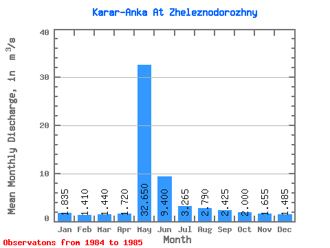
| Statistic | Jan | Feb | Mar | Apr | May | Jun | Jul | Aug | Sep | Oct | Nov | Dec | Annual |
|---|---|---|---|---|---|---|---|---|---|---|---|---|---|
| Mean | 1.83 | 1.41 | 1.44 | 1.72 | 32.65 | 9.40 | 3.27 | 2.79 | 2.42 | 2.00 | 1.66 | 1.48 | 5.17 |
| Standard Deviation | 0.40 | 0.42 | 0.76 | 0.03 | 6.86 | 1.41 | 0.02 | 0.44 | 0.16 | 0.18 | 0.16 | 0.33 | 0.69 |
| Min | 1.55 | 1.11 | 0.90 | 1.70 | 27.80 | 8.40 | 3.25 | 2.48 | 2.31 | 1.87 | 1.54 | 1.25 | 4.69 |
| Max | 2.12 | 1.71 | 1.98 | 1.74 | 37.50 | 10.40 | 3.28 | 3.10 | 2.54 | 2.13 | 1.77 | 1.72 | 5.66 |
| Coefficient of Variation | 0.22 | 0.30 | 0.53 | 0.02 | 0.21 | 0.15 | 0.01 | 0.16 | 0.07 | 0.09 | 0.10 | 0.22 | 0.13 |
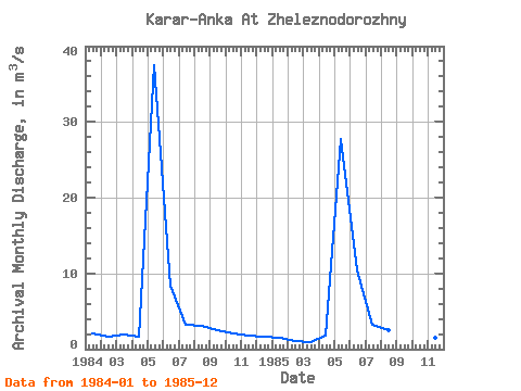
| Year | Jan | Feb | Mar | Apr | May | Jun | Jul | Aug | Sep | Oct | Nov | Dec | Annual | 1984 | 2.12 | 1.71 | 1.98 | 1.70 | 37.50 | 8.40 | 3.25 | 3.10 | 2.54 | 2.13 | 1.77 | 1.72 | 5.66 | 1985 | 1.55 | 1.11 | 0.90 | 1.74 | 27.80 | 10.40 | 3.28 | 2.48 | 2.31 | 1.87 | 1.54 | 1.25 | 4.69 |
|---|
 Return to R-Arctic Net Home Page