|
|
|||||||||||||||||
| Point ID: 8279 | Downloads | Plots | Site Data | Code: 8408 |
|
|
|||||||||||||||||
| Download | |
|---|---|
| Site Descriptor Information | Site Time Series Data |
| Link to all available data | |
|
|
| View: | Statistics | Time Series |
| Units: | m3/s |
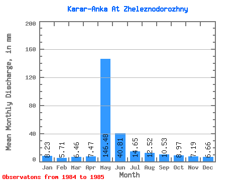
| Statistic | Jan | Feb | Mar | Apr | May | Jun | Jul | Aug | Sep | Oct | Nov | Dec | Annual |
|---|---|---|---|---|---|---|---|---|---|---|---|---|---|
| Mean | 8.23 | 5.76 | 6.46 | 7.47 | 146.46 | 40.81 | 14.65 | 12.52 | 10.53 | 8.97 | 7.19 | 6.66 | 273.46 |
| Standard Deviation | 1.81 | 1.73 | 3.43 | 0.12 | 30.77 | 6.14 | 0.10 | 1.97 | 0.71 | 0.82 | 0.71 | 1.49 | 36.41 |
| Min | 6.95 | 4.54 | 4.04 | 7.38 | 124.70 | 36.47 | 14.58 | 11.12 | 10.03 | 8.39 | 6.69 | 5.61 | 247.71 |
| Max | 9.51 | 6.99 | 8.88 | 7.55 | 168.22 | 45.15 | 14.71 | 13.91 | 11.03 | 9.55 | 7.69 | 7.72 | 299.21 |
| Coefficient of Variation | 0.22 | 0.30 | 0.53 | 0.02 | 0.21 | 0.15 | 0.01 | 0.16 | 0.07 | 0.09 | 0.10 | 0.22 | 0.13 |
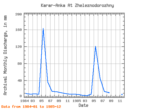
| Year | Jan | Feb | Mar | Apr | May | Jun | Jul | Aug | Sep | Oct | Nov | Dec | Annual | 1984 | 9.51 | 6.99 | 8.88 | 7.38 | 168.22 | 36.47 | 14.58 | 13.91 | 11.03 | 9.55 | 7.69 | 7.72 | 299.21 | 1985 | 6.95 | 4.54 | 4.04 | 7.55 | 124.70 | 45.15 | 14.71 | 11.12 | 10.03 | 8.39 | 6.69 | 5.61 | 247.71 |
|---|
 Return to R-Arctic Net Home Page