|
|
|||||||||||||||||
| Point ID: 8278 | Downloads | Plots | Site Data | Code: 8406 |
|
|
|||||||||||||||||
| Download | |
|---|---|
| Site Descriptor Information | Site Time Series Data |
| Link to all available data | |
|
|
| View: | Statistics | Time Series |
| Units: | mm |
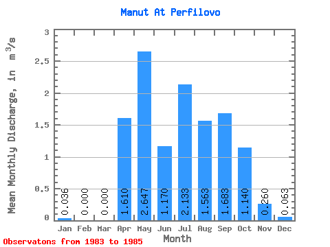
| Statistic | Jan | Feb | Mar | Apr | May | Jun | Jul | Aug | Sep | Oct | Nov | Dec | Annual |
|---|---|---|---|---|---|---|---|---|---|---|---|---|---|
| Mean | 0.04 | 0.00 | 0.00 | 1.61 | 2.65 | 1.17 | 2.13 | 1.56 | 1.68 | 1.14 | 0.26 | 0.06 | 1.04 |
| Standard Deviation | 0.03 | 0.00 | 0.00 | 1.99 | 0.81 | 0.41 | 0.30 | 0.57 | 1.00 | 0.06 | 0.06 | 0.11 | |
| Min | 0.00 | 0.00 | 0.00 | 0.20 | 2.00 | 0.88 | 1.79 | 0.96 | 0.55 | 1.10 | 0.22 | 0.00 | 1.04 |
| Max | 0.06 | 0.00 | 0.00 | 3.02 | 3.56 | 1.46 | 2.37 | 2.10 | 2.45 | 1.18 | 0.30 | 0.19 | 1.04 |
| Coefficient of Variation | 0.89 | 1.24 | 0.31 | 0.35 | 0.14 | 0.37 | 0.59 | 0.05 | 0.22 | 1.73 |
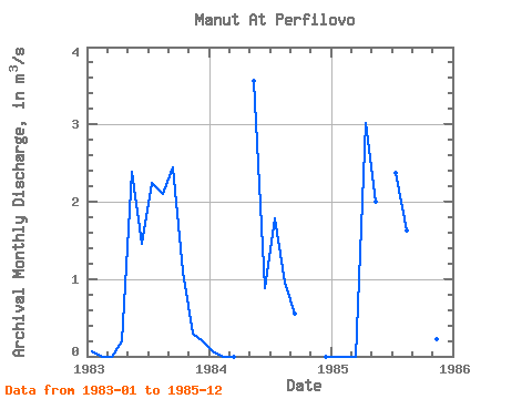
| Year | Jan | Feb | Mar | Apr | May | Jun | Jul | Aug | Sep | Oct | Nov | Dec | Annual | 1983 | 0.06 | 0.00 | 0.00 | 0.20 | 2.38 | 1.46 | 2.24 | 2.10 | 2.45 | 1.10 | 0.30 | 0.19 | 1.04 | 1984 | 0.05 | 0.00 | 0.00 | 3.56 | 0.88 | 1.79 | 0.96 | 0.55 | 0.00 | 1985 | 0.00 | 0.00 | 0.00 | 3.02 | 2.00 | 2.37 | 1.63 | 2.05 | 1.18 | 0.22 | 0.00 |
|---|
 Return to R-Arctic Net Home Page