|
|
|||||||||||||||||
| Point ID: 8278 | Downloads | Plots | Site Data | Code: 8406 |
|
|
|||||||||||||||||
| Download | |
|---|---|
| Site Descriptor Information | Site Time Series Data |
| Link to all available data | |

|

|
| View: | Statistics | Time Series |
| Units: | m3/s |
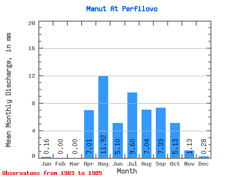
| Statistic | Jan | Feb | Mar | Apr | May | Jun | Jul | Aug | Sep | Oct | Nov | Dec | Annual |
|---|---|---|---|---|---|---|---|---|---|---|---|---|---|
| Mean | 0.16 | 0.00 | 0.00 | 7.01 | 11.91 | 5.10 | 9.60 | 7.04 | 7.33 | 5.13 | 1.13 | 0.28 | 55.17 |
| Standard Deviation | 0.14 | 0.00 | 0.00 | 8.69 | 3.66 | 1.79 | 1.37 | 2.58 | 4.36 | 0.26 | 0.25 | 0.49 | |
| Min | 0.00 | 0.00 | 0.00 | 0.87 | 9.00 | 3.83 | 8.06 | 4.32 | 2.40 | 4.95 | 0.96 | 0.00 | 55.17 |
| Max | 0.28 | 0.00 | 0.00 | 13.16 | 16.02 | 6.36 | 10.67 | 9.45 | 10.67 | 5.31 | 1.31 | 0.85 | 55.17 |
| Coefficient of Variation | 0.89 | 1.24 | 0.31 | 0.35 | 0.14 | 0.37 | 0.59 | 0.05 | 0.22 | 1.73 |
| Year | Jan | Feb | Mar | Apr | May | Jun | Jul | Aug | Sep | Oct | Nov | Dec | Annual | 1983 | 0.28 | 0.00 | 0.00 | 0.87 | 10.71 | 6.36 | 10.08 | 9.45 | 10.67 | 4.95 | 1.31 | 0.85 | 55.17 | 1984 | 0.21 | 0.00 | 0.00 | 16.02 | 3.83 | 8.06 | 4.32 | 2.40 | 0.00 | 1985 | 0.00 | 0.00 | 0.00 | 13.16 | 9.00 | 10.67 | 7.34 | 8.93 | 5.31 | 0.96 | 0.00 |
|---|
 Return to R-Arctic Net Home Page