|
|
|||||||||||||||||
| Point ID: 8273 | Downloads | Plots | Site Data | Code: 8392 |
|
|
|||||||||||||||||
| Download | |
|---|---|
| Site Descriptor Information | Site Time Series Data |
| Link to all available data | |
|
|
| View: | Statistics | Time Series |
| Units: | mm |
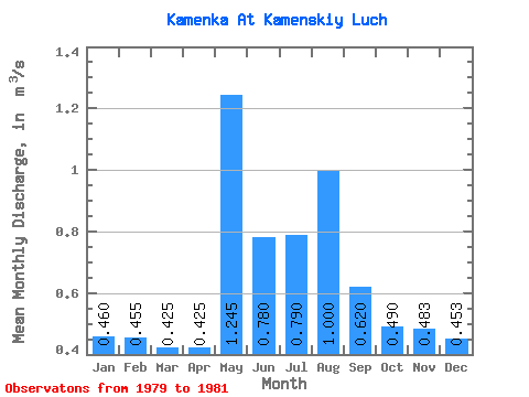
| Statistic | Jan | Feb | Mar | Apr | May | Jun | Jul | Aug | Sep | Oct | Nov | Dec | Annual |
|---|---|---|---|---|---|---|---|---|---|---|---|---|---|
| Mean | 0.46 | 0.46 | 0.42 | 0.42 | 1.25 | 0.78 | 0.79 | 1.00 | 0.62 | 0.49 | 0.48 | 0.45 | 0.65 |
| Standard Deviation | 0.14 | 0.16 | 0.09 | 0.11 | 0.06 | 0.27 | 0.31 | 0.41 | 0.06 | 0.10 | 0.10 | 0.07 | 0.07 |
| Min | 0.36 | 0.34 | 0.36 | 0.35 | 1.20 | 0.59 | 0.57 | 0.71 | 0.58 | 0.39 | 0.41 | 0.38 | 0.60 |
| Max | 0.56 | 0.57 | 0.49 | 0.50 | 1.29 | 0.97 | 1.01 | 1.29 | 0.66 | 0.58 | 0.59 | 0.51 | 0.69 |
| Coefficient of Variation | 0.31 | 0.36 | 0.22 | 0.25 | 0.05 | 0.34 | 0.39 | 0.41 | 0.09 | 0.20 | 0.20 | 0.15 | 0.10 |
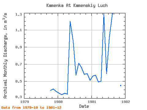
| Year | Jan | Feb | Mar | Apr | May | Jun | Jul | Aug | Sep | Oct | Nov | Dec | Annual | 1979 | 0.39 | 0.41 | 0.38 | 1980 | 0.36 | 0.34 | 0.36 | 0.35 | 1.20 | 0.97 | 0.57 | 0.71 | 0.66 | 0.58 | 0.59 | 0.51 | 0.60 | 1981 | 0.56 | 0.57 | 0.49 | 0.50 | 1.29 | 0.59 | 1.01 | 1.29 | 0.58 | 0.50 | 0.45 | 0.47 | 0.69 |
|---|
 Return to R-Arctic Net Home Page