|
|
|||||||||||||||||
| Point ID: 8273 | Downloads | Plots | Site Data | Code: 8392 |
|
|
|||||||||||||||||
| Download | |
|---|---|
| Site Descriptor Information | Site Time Series Data |
| Link to all available data | |
|
|
| View: | Statistics | Time Series |
| Units: | m3/s |
| Statistic | Jan | Feb | Mar | Apr | May | Jun | Jul | Aug | Sep | Oct | Nov | Dec | Annual |
|---|---|---|---|---|---|---|---|---|---|---|---|---|---|
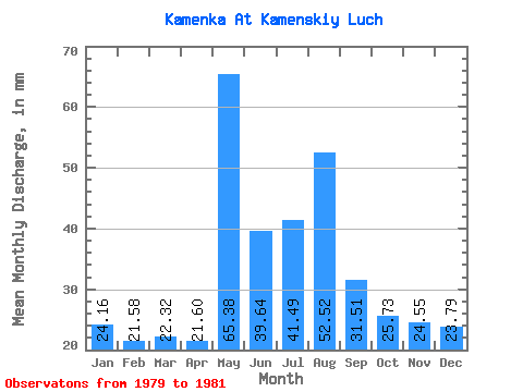
| Mean | 24.16 | 21.77 | 22.32 | 21.60 | 65.38 | 39.64 | 41.48 | 52.51 | 31.51 | 25.73 | 24.57 | 23.80 | 399.66 |
| Standard Deviation | 7.43 | 7.78 | 4.83 | 5.39 | 3.34 | 13.66 | 16.34 | 21.54 | 2.88 | 5.01 | 4.80 | 3.50 | 40.11 |
| Min | 18.90 | 16.27 | 18.90 | 17.79 | 63.01 | 29.99 | 29.93 | 37.28 | 29.48 | 20.48 | 20.84 | 19.95 | 371.29 |
| Max | 29.41 | 27.27 | 25.73 | 25.41 | 67.74 | 49.30 | 53.03 | 67.74 | 33.54 | 30.46 | 29.99 | 26.78 | 428.02 |
| Coefficient of Variation | 0.31 | 0.36 | 0.22 | 0.25 | 0.05 | 0.34 | 0.39 | 0.41 | 0.09 | 0.20 | 0.20 | 0.15 | 0.10 |
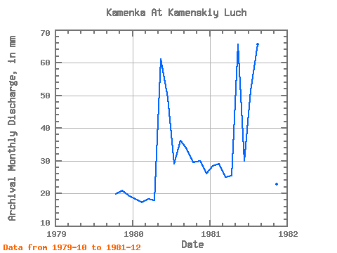
| Year | Jan | Feb | Mar | Apr | May | Jun | Jul | Aug | Sep | Oct | Nov | Dec | Annual | 1979 | 20.48 | 20.84 | 19.95 | 1980 | 18.90 | 16.27 | 18.90 | 17.79 | 63.01 | 49.30 | 29.93 | 37.28 | 33.54 | 30.46 | 29.99 | 26.78 | 371.29 | 1981 | 29.41 | 27.27 | 25.73 | 25.41 | 67.74 | 29.99 | 53.03 | 67.74 | 29.48 | 26.25 | 22.87 | 24.68 | 428.02 |
|---|
 Return to R-Arctic Net Home Page