|
|
|||||||||||||||||
| Point ID: 8256 | Downloads | Plots | Site Data | Code: 8351 |
|
|
|||||||||||||||||
| Download | |
|---|---|
| Site Descriptor Information | Site Time Series Data |
| Link to all available data | |
| View: | Time Series | All |
| Units: | m3/s |
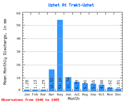
| Statistic | Jan | Feb | Mar | Apr | May | Jun | Jul | Aug | Sep | Oct | Nov | Dec | Annual |
|---|---|---|---|---|---|---|---|---|---|---|---|---|---|
| Mean | 1.28 | 1.14 | 1.28 | 16.53 | 54.09 | 10.74 | 6.99 | 5.89 | 5.55 | 4.88 | 2.62 | 1.81 | 114.35 |
| Standard Deviation | 0.45 | 0.42 | 0.42 | 13.34 | 31.27 | 4.14 | 4.45 | 4.33 | 4.93 | 3.36 | 1.33 | 1.01 | 34.90 |
| Min | 0.38 | 0.64 | 0.61 | 1.50 | 11.15 | 4.33 | 2.47 | 2.56 | 2.30 | 2.56 | 1.06 | 0.68 | 63.91 |
| Max | 2.38 | 2.25 | 2.47 | 45.38 | 140.75 | 23.27 | 25.32 | 22.58 | 28.66 | 20.20 | 6.72 | 5.67 | 196.85 |
| Coefficient of Variation | 0.35 | 0.36 | 0.33 | 0.81 | 0.58 | 0.39 | 0.64 | 0.73 | 0.89 | 0.69 | 0.51 | 0.56 | 0.30 |
 Return to R-Arctic Net Home Page