|
|
|||||||||||||||||
| Point ID: 8256 | Downloads | Plots | Site Data | Code: 8351 |
|
|
|||||||||||||||||
| Download | |
|---|---|
| Site Descriptor Information | Site Time Series Data |
| Link to all available data | |
| View: | Time Series | All |
| Units: | mm |
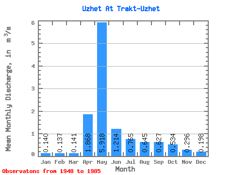
| Statistic | Jan | Feb | Mar | Apr | May | Jun | Jul | Aug | Sep | Oct | Nov | Dec | Annual |
|---|---|---|---|---|---|---|---|---|---|---|---|---|---|
| Mean | 0.14 | 0.14 | 0.14 | 1.87 | 5.92 | 1.21 | 0.77 | 0.65 | 0.63 | 0.53 | 0.30 | 0.20 | 1.06 |
| Standard Deviation | 0.05 | 0.05 | 0.05 | 1.51 | 3.42 | 0.47 | 0.49 | 0.47 | 0.56 | 0.37 | 0.15 | 0.11 | 0.32 |
| Min | 0.04 | 0.08 | 0.07 | 0.17 | 1.22 | 0.49 | 0.27 | 0.28 | 0.26 | 0.28 | 0.12 | 0.07 | 0.59 |
| Max | 0.26 | 0.27 | 0.27 | 5.13 | 15.40 | 2.63 | 2.77 | 2.47 | 3.24 | 2.21 | 0.76 | 0.62 | 1.83 |
| Coefficient of Variation | 0.35 | 0.36 | 0.33 | 0.81 | 0.58 | 0.39 | 0.64 | 0.73 | 0.89 | 0.69 | 0.51 | 0.56 | 0.30 |
 Return to R-Arctic Net Home Page