|
|
|||||||||||||||||
| Point ID: 8241 | Downloads | Plots | Site Data | Code: 8314 |
|
|
|||||||||||||||||
| Download | |
|---|---|
| Site Descriptor Information | Site Time Series Data |
| Link to all available data | |
|
|
| View: | Statistics | Time Series |
| Units: | mm |
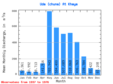
| Statistic | Jan | Feb | Mar | Apr | May | Jun | Jul | Aug | Sep | Oct | Nov | Dec | Annual |
|---|---|---|---|---|---|---|---|---|---|---|---|---|---|
| Mean | 52.36 | 40.99 | 38.71 | 141.92 | 783.94 | 584.40 | 507.09 | 518.87 | 406.76 | 228.78 | 83.42 | 65.11 | 289.56 |
| Standard Deviation | 9.91 | 8.02 | 8.17 | 128.15 | 223.33 | 158.88 | 160.63 | 170.95 | 163.16 | 74.48 | 18.08 | 10.05 | 53.52 |
| Min | 30.80 | 23.80 | 22.40 | 22.00 | 423.00 | 381.00 | 65.30 | 338.00 | 266.00 | 158.00 | 51.20 | 45.50 | 208.40 |
| Max | 77.10 | 63.20 | 59.70 | 537.00 | 1290.00 | 1070.00 | 882.00 | 1150.00 | 1120.00 | 602.00 | 147.00 | 86.60 | 509.96 |
| Coefficient of Variation | 0.19 | 0.20 | 0.21 | 0.90 | 0.28 | 0.27 | 0.32 | 0.33 | 0.40 | 0.33 | 0.22 | 0.15 | 0.18 |
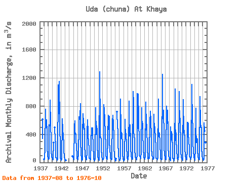
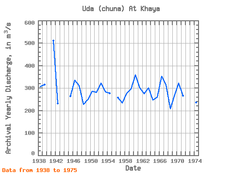
| Year | Jan | Feb | Mar | Apr | May | Jun | Jul | Aug | Sep | Oct | Nov | Dec | Annual | 1937 | 344.00 | 611.00 | 1938 | 48.80 | 44.30 | 45.50 | 221.00 | 754.00 | 663.00 | 491.00 | 605.00 | 419.00 | 213.00 | 97.40 | 62.70 | 305.39 | 1939 | 52.40 | 48.60 | 52.00 | 537.00 | 532.00 | 519.00 | 882.00 | 550.00 | 306.00 | 169.00 | 73.40 | 65.70 | 315.59 | 1940 | 63.10 | 36.20 | 39.50 | 281.00 | 501.00 | 415.00 | 400.00 | 206.00 | 67.40 | 65.40 | 1941 | 56.00 | 38.90 | 29.90 | 45.00 | 1100.00 | 1070.00 | 691.00 | 1150.00 | 1120.00 | 602.00 | 147.00 | 69.70 | 509.96 | 1942 | 47.80 | 31.20 | 29.40 | 55.10 | 578.00 | 622.00 | 462.00 | 375.00 | 266.00 | 190.00 | 65.30 | 53.80 | 231.30 | 1943 | 41.80 | 34.60 | 34.70 | 1944 | 93.10 | 73.80 | 1945 | 62.10 | 41.80 | 39.10 | 502.00 | 592.00 | 436.00 | 402.00 | 404.00 | 310.00 | 231.00 | 94.50 | 57.10 | 264.30 | 1946 | 53.40 | 39.80 | 40.20 | 122.00 | 522.00 | 647.00 | 611.00 | 645.00 | 834.00 | 329.00 | 101.00 | 77.30 | 335.14 | 1947 | 50.10 | 33.10 | 41.30 | 400.00 | 695.00 | 492.00 | 625.00 | 468.00 | 485.00 | 275.00 | 81.60 | 70.20 | 309.69 | 1948 | 52.80 | 42.50 | 42.10 | 154.00 | 423.00 | 603.00 | 421.00 | 380.00 | 282.00 | 200.00 | 60.60 | 60.80 | 226.82 | 1949 | 46.70 | 40.50 | 37.00 | 285.00 | 494.00 | 382.00 | 429.00 | 489.00 | 425.00 | 232.00 | 77.20 | 45.50 | 248.57 | 1950 | 31.40 | 27.70 | 22.40 | 52.20 | 742.00 | 779.00 | 398.00 | 522.00 | 445.00 | 265.00 | 81.70 | 62.40 | 285.73 | 1951 | 55.90 | 40.00 | 33.20 | 45.40 | 1290.00 | 517.00 | 357.00 | 360.00 | 326.00 | 198.00 | 89.00 | 56.20 | 280.64 | 1952 | 49.50 | 41.80 | 38.20 | 66.60 | 824.00 | 736.00 | 623.00 | 660.00 | 364.00 | 287.00 | 95.80 | 65.20 | 320.93 | 1953 | 49.40 | 44.70 | 43.50 | 358.00 | 668.00 | 466.00 | 495.00 | 657.00 | 283.00 | 205.00 | 78.30 | 58.20 | 283.84 | 1954 | 53.80 | 45.90 | 37.50 | 49.50 | 621.00 | 565.00 | 673.00 | 549.00 | 364.00 | 221.00 | 87.00 | 47.60 | 276.19 | 1955 | 38.40 | 28.30 | 25.30 | 51.60 | 719.00 | 497.00 | 454.00 | 299.00 | 96.90 | 63.30 | 1956 | 37.90 | 31.90 | 31.20 | 70.30 | 899.00 | 457.00 | 402.00 | 340.00 | 412.00 | 249.00 | 112.00 | 53.00 | 257.94 | 1957 | 30.80 | 23.80 | 23.20 | 48.50 | 546.00 | 610.00 | 332.00 | 403.00 | 414.00 | 242.00 | 68.90 | 59.10 | 233.44 | 1958 | 45.60 | 40.00 | 37.60 | 132.00 | 872.00 | 626.00 | 379.00 | 536.00 | 290.00 | 216.00 | 82.90 | 67.90 | 277.08 | 1959 | 58.20 | 47.70 | 46.50 | 76.90 | 1010.00 | 839.00 | 439.00 | 366.00 | 328.00 | 195.00 | 77.80 | 68.70 | 296.07 | 1960 | 51.20 | 43.60 | 41.20 | 108.00 | 977.00 | 546.00 | 483.00 | 970.00 | 631.00 | 247.00 | 100.00 | 86.30 | 357.02 | 1961 | 77.10 | 63.20 | 56.40 | 162.00 | 778.00 | 596.00 | 577.00 | 542.00 | 396.00 | 212.00 | 69.80 | 73.50 | 300.25 | 1962 | 63.00 | 50.90 | 46.60 | 97.00 | 856.00 | 459.00 | 682.00 | 404.00 | 297.00 | 220.00 | 51.20 | 72.90 | 274.97 | 1963 | 69.40 | 56.40 | 59.70 | 77.60 | 641.00 | 584.00 | 726.00 | 587.00 | 384.00 | 222.00 | 99.80 | 86.60 | 299.46 | 1964 | 71.10 | 48.30 | 47.00 | 62.70 | 682.00 | 426.00 | 505.00 | 433.00 | 399.00 | 174.00 | 57.90 | 58.80 | 247.07 | 1965 | 53.20 | 41.30 | 43.50 | 62.20 | 902.00 | 405.00 | 368.00 | 407.00 | 420.00 | 275.00 | 77.80 | 53.80 | 259.07 | 1966 | 46.00 | 48.60 | 39.80 | 50.10 | 1250.00 | 658.00 | 617.00 | 739.00 | 378.00 | 225.00 | 94.50 | 79.90 | 352.16 | 1967 | 52.60 | 41.10 | 39.20 | 126.00 | 798.00 | 557.00 | 592.00 | 740.00 | 415.00 | 230.00 | 92.10 | 79.90 | 313.57 | 1968 | 63.20 | 43.30 | 39.30 | 22.00 | 506.00 | 381.00 | 316.00 | 435.00 | 378.00 | 196.00 | 62.80 | 58.20 | 208.40 | 1969 | 39.80 | 27.00 | 25.90 | 68.90 | 1040.00 | 612.00 | 312.00 | 419.00 | 321.00 | 175.00 | 62.20 | 56.70 | 263.29 | 1970 | 50.40 | 41.80 | 37.60 | 104.00 | 1010.00 | 739.00 | 738.00 | 524.00 | 311.00 | 158.00 | 71.00 | 64.10 | 320.74 | 1971 | 50.90 | 38.80 | 33.30 | 159.00 | 890.00 | 419.00 | 470.00 | 451.00 | 320.00 | 202.00 | 93.70 | 60.90 | 265.72 | 1972 | 51.20 | 37.70 | 36.40 | 180.00 | 570.00 | 569.00 | 548.00 | 391.00 | 319.00 | 188.00 | 89.60 | 82.70 | 255.22 | 1973 | 62.10 | 47.00 | 45.60 | 92.80 | 1110.00 | 992.00 | 651.00 | 461.00 | 268.00 | 168.00 | 69.00 | 66.80 | 336.11 | 1974 | 56.40 | 36.90 | 35.30 | 201.00 | 772.00 | 475.00 | 283.00 | 338.00 | 326.00 | 177.00 | 71.90 | 62.80 | 236.28 | 1975 | 53.10 | 48.60 | 39.30 | 70.70 | 932.00 | 558.00 | 497.00 | 530.00 | 471.00 | 210.00 | 94.50 | 61.50 | 297.14 | 1976 | 53.10 | 39.90 | 35.70 | 53.80 | 562.00 | 449.00 | 65.30 | 631.00 | 285.00 | 162.00 |
|---|
 Return to R-Arctic Net Home Page