|
|
|||||||||||||||||
| Point ID: 8214 | Downloads | Plots | Site Data | Code: 8232 |
|
|
|||||||||||||||||
| Download | |
|---|---|
| Site Descriptor Information | Site Time Series Data |
| Link to all available data | |
|
|
| View: | Statistics | Time Series |
| Units: | mm |
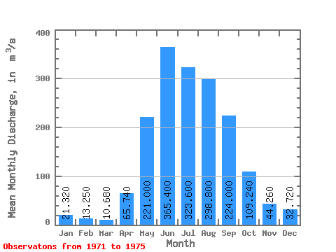
| Statistic | Jan | Feb | Mar | Apr | May | Jun | Jul | Aug | Sep | Oct | Nov | Dec | Annual |
|---|---|---|---|---|---|---|---|---|---|---|---|---|---|
| Mean | 21.32 | 13.25 | 10.68 | 65.74 | 221.00 | 365.40 | 323.60 | 298.80 | 224.00 | 109.24 | 44.26 | 32.72 | 144.17 |
| Standard Deviation | 4.77 | 4.66 | 5.16 | 24.21 | 67.61 | 159.65 | 115.12 | 68.50 | 61.56 | 17.94 | 5.77 | 8.91 | 26.78 |
| Min | 17.70 | 6.25 | 5.05 | 53.60 | 146.00 | 193.00 | 230.00 | 190.00 | 165.00 | 79.20 | 37.00 | 24.20 | 116.40 |
| Max | 29.70 | 18.90 | 18.40 | 109.00 | 294.00 | 619.00 | 454.00 | 359.00 | 320.00 | 124.00 | 52.00 | 47.60 | 179.70 |
| Coefficient of Variation | 0.22 | 0.35 | 0.48 | 0.37 | 0.31 | 0.44 | 0.36 | 0.23 | 0.28 | 0.16 | 0.13 | 0.27 | 0.19 |
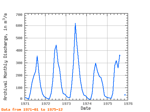
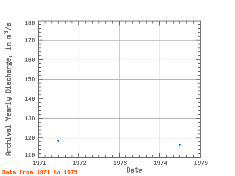
| Year | Jan | Feb | Mar | Apr | May | Jun | Jul | Aug | Sep | Oct | Nov | Dec | Annual | 1971 | 19.90 | 13.50 | 8.76 | 55.50 | 146.00 | 193.00 | 231.00 | 356.00 | 208.00 | 111.00 | 47.80 | 28.90 | 118.28 | 1972 | 20.00 | 12.20 | 8.19 | 56.40 | 157.00 | 399.00 | 444.00 | 295.00 | 245.00 | 110.00 | 52.00 | 47.60 | 153.87 | 1973 | 29.70 | 18.90 | 18.40 | 109.00 | 294.00 | 619.00 | 454.00 | 294.00 | 165.00 | 79.20 | 42.10 | 33.10 | 179.70 | 1974 | 17.70 | 6.25 | 5.05 | 53.60 | 231.00 | 298.00 | 230.00 | 190.00 | 182.00 | 122.00 | 37.00 | 24.20 | 116.40 | 1975 | 19.30 | 15.40 | 13.00 | 54.20 | 277.00 | 318.00 | 259.00 | 359.00 | 320.00 | 124.00 | 42.40 | 29.80 | 152.59 |
|---|
 Return to R-Arctic Net Home Page