|
|
|||||||||||||||||
| Point ID: 8214 | Downloads | Plots | Site Data | Code: 8232 |
|
|
|||||||||||||||||
| Download | |
|---|---|
| Site Descriptor Information | Site Time Series Data |
| Link to all available data | |
|
|
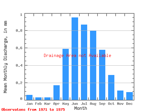
| View: | Statistics | Time Series |
| Units: | m3/s |
| Statistic | Jan | Feb | Mar | Apr | May | Jun | Jul | Aug | Sep | Oct | Nov | Dec | Annual |
|---|---|---|---|---|---|---|---|---|---|---|---|---|---|
| Mean | |||||||||||||
| Standard Deviation | |||||||||||||
| Min | |||||||||||||
| Max | |||||||||||||
| Coefficient of Variation | 0.22 | 0.35 | 0.48 | 0.37 | 0.31 | 0.44 | 0.36 | 0.23 | 0.28 | 0.16 | 0.13 | 0.27 | 0.19 |
| Year | Jan | Feb | Mar | Apr | May | Jun | Jul | Aug | Sep | Oct | Nov | Dec | Annual | 1971 | 1972 | 1973 | 1974 | 1975 |
|---|
 Return to R-Arctic Net Home Page