|
|
|||||||||||||||||
| Point ID: 8203 | Downloads | Plots | Site Data | Code: 8199 |
|
|
|||||||||||||||||
| Download | |
|---|---|
| Site Descriptor Information | Site Time Series Data |
| Link to all available data | |
|
|
| View: | Statistics | Time Series |
| Units: | mm |
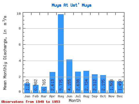
| Statistic | Jan | Feb | Mar | Apr | May | Jun | Jul | Aug | Sep | Oct | Nov | Dec | Annual |
|---|---|---|---|---|---|---|---|---|---|---|---|---|---|
| Mean | 1.21 | 0.98 | 0.77 | 2.61 | 9.78 | 4.16 | 2.64 | 2.73 | 2.31 | 2.19 | 1.51 | 1.45 | 2.73 |
| Standard Deviation | 0.60 | 0.57 | 0.44 | 2.39 | 4.43 | 1.00 | 0.75 | 0.67 | 0.60 | 0.53 | 0.47 | 0.69 | 0.58 |
| Min | 0.67 | 0.40 | 0.30 | 1.36 | 6.57 | 3.08 | 1.82 | 1.68 | 1.61 | 1.84 | 1.03 | 0.95 | 2.06 |
| Max | 2.05 | 1.75 | 1.35 | 6.20 | 16.20 | 5.24 | 3.41 | 3.52 | 3.20 | 2.97 | 2.16 | 2.45 | 3.11 |
| Coefficient of Variation | 0.49 | 0.58 | 0.58 | 0.92 | 0.45 | 0.24 | 0.28 | 0.25 | 0.26 | 0.24 | 0.31 | 0.48 | 0.21 |
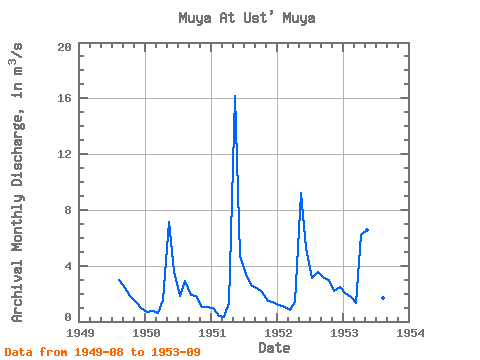
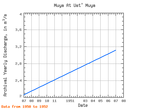
| Year | Jan | Feb | Mar | Apr | May | Jun | Jul | Aug | Sep | Oct | Nov | Dec | Annual | 1949 | 2.95 | 2.43 | 1.84 | 1.38 | 0.95 | 1950 | 0.67 | 0.74 | 0.60 | 1.51 | 7.14 | 3.57 | 1.82 | 2.89 | 1.92 | 1.86 | 1.03 | 1.01 | 2.06 | 1951 | 0.95 | 0.40 | 0.30 | 1.36 | 16.20 | 4.73 | 3.41 | 2.63 | 2.40 | 2.11 | 1.46 | 1.39 | 3.11 | 1952 | 1.17 | 1.04 | 0.81 | 1.38 | 9.19 | 5.24 | 3.12 | 3.52 | 3.20 | 2.97 | 2.16 | 2.45 | 3.02 | 1953 | 2.05 | 1.75 | 1.35 | 6.20 | 6.57 | 3.08 | 2.20 | 1.68 | 1.61 |
|---|
 Return to R-Arctic Net Home Page