|
|
|||||||||||||||||
| Point ID: 8203 | Downloads | Plots | Site Data | Code: 8199 |
|
|
|||||||||||||||||
| Download | |
|---|---|
| Site Descriptor Information | Site Time Series Data |
| Link to all available data | |
|
|
| View: | Statistics | Time Series |
| Units: | m3/s |
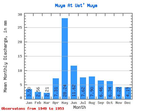
| Statistic | Jan | Feb | Mar | Apr | May | Jun | Jul | Aug | Sep | Oct | Nov | Dec | Annual |
|---|---|---|---|---|---|---|---|---|---|---|---|---|---|
| Mean | 3.50 | 2.59 | 2.21 | 7.30 | 28.24 | 11.62 | 7.62 | 7.90 | 6.46 | 6.34 | 4.21 | 4.19 | 93.01 |
| Standard Deviation | 1.72 | 1.51 | 1.28 | 6.69 | 12.79 | 2.80 | 2.17 | 1.94 | 1.69 | 1.53 | 1.32 | 2.01 | 19.77 |
| Min | 1.94 | 1.05 | 0.87 | 3.80 | 18.98 | 8.61 | 5.26 | 4.85 | 4.50 | 5.32 | 2.88 | 2.74 | 70.25 |
| Max | 5.92 | 4.61 | 3.90 | 17.34 | 46.80 | 14.65 | 9.85 | 10.17 | 8.95 | 8.58 | 6.04 | 7.08 | 105.94 |
| Coefficient of Variation | 0.49 | 0.58 | 0.58 | 0.92 | 0.45 | 0.24 | 0.28 | 0.25 | 0.26 | 0.24 | 0.31 | 0.48 | 0.21 |
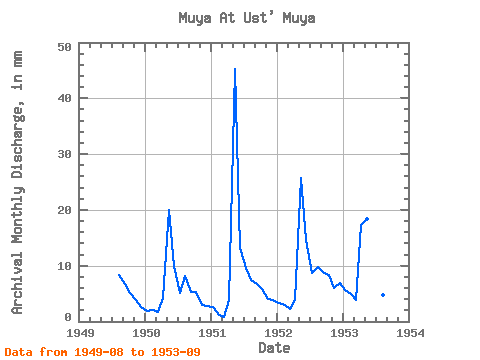
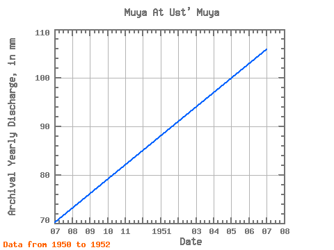
| Year | Jan | Feb | Mar | Apr | May | Jun | Jul | Aug | Sep | Oct | Nov | Dec | Annual | 1949 | 8.52 | 6.80 | 5.32 | 3.86 | 2.74 | 1950 | 1.94 | 1.95 | 1.73 | 4.22 | 20.63 | 9.98 | 5.26 | 8.35 | 5.37 | 5.37 | 2.88 | 2.92 | 70.25 | 1951 | 2.74 | 1.05 | 0.87 | 3.80 | 46.80 | 13.23 | 9.85 | 7.60 | 6.71 | 6.10 | 4.08 | 4.02 | 105.94 | 1952 | 3.38 | 2.74 | 2.34 | 3.86 | 26.55 | 14.65 | 9.01 | 10.17 | 8.95 | 8.58 | 6.04 | 7.08 | 102.85 | 1953 | 5.92 | 4.61 | 3.90 | 17.34 | 18.98 | 8.61 | 6.36 | 4.85 | 4.50 |
|---|
 Return to R-Arctic Net Home Page