|
|
|||||||||||||||||
| Point ID: 8201 | Downloads | Plots | Site Data | Code: 8196 |
|
|
|||||||||||||||||
| Download | |
|---|---|
| Site Descriptor Information | Site Time Series Data |
| Link to all available data | |
|
|
| View: | Statistics | Time Series |
| Units: | mm |
| Statistic | Jan | Feb | Mar | Apr | May | Jun | Jul | Aug | Sep | Oct | Nov | Dec | Annual |
|---|---|---|---|---|---|---|---|---|---|---|---|---|---|
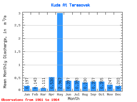
| Mean | 0.20 | 0.14 | 0.11 | 0.53 | 2.97 | 0.40 | 0.39 | 0.33 | 0.36 | 0.35 | 0.25 | 0.20 | 0.43 |
| Standard Deviation | 0.10 | 0.06 | 0.04 | 0.23 | 1.67 | 0.09 | 0.05 | 0.06 | 0.09 | 0.12 | 0.10 | 0.09 | 0.05 |
| Min | 0.12 | 0.09 | 0.06 | 0.27 | 1.88 | 0.30 | 0.36 | 0.28 | 0.27 | 0.27 | 0.17 | 0.14 | 0.39 |
| Max | 0.31 | 0.20 | 0.15 | 0.69 | 4.89 | 0.46 | 0.45 | 0.39 | 0.45 | 0.44 | 0.36 | 0.30 | 0.47 |
| Coefficient of Variation | 0.51 | 0.39 | 0.39 | 0.43 | 0.56 | 0.21 | 0.12 | 0.17 | 0.25 | 0.34 | 0.41 | 0.42 | 0.12 |
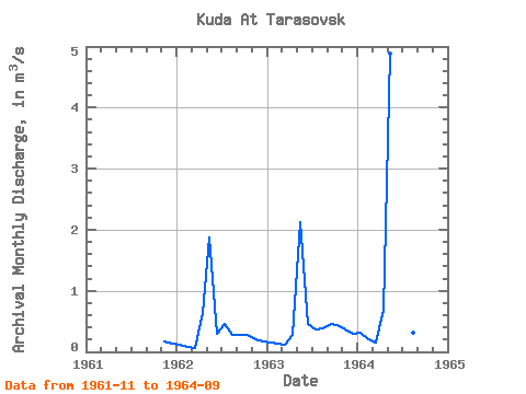
| Year | Jan | Feb | Mar | Apr | May | Jun | Jul | Aug | Sep | Oct | Nov | Dec | Annual | 1961 | 0.17 | 0.14 | 1962 | 0.12 | 0.09 | 0.06 | 0.63 | 1.88 | 0.30 | 0.45 | 0.28 | 0.27 | 0.27 | 0.21 | 0.17 | 0.39 | 1963 | 0.16 | 0.14 | 0.12 | 0.27 | 2.13 | 0.46 | 0.37 | 0.39 | 0.45 | 0.44 | 0.36 | 0.30 | 0.47 | 1964 | 0.31 | 0.20 | 0.15 | 0.69 | 4.89 | 0.43 | 0.36 | 0.32 | 0.35 |
|---|
 Return to R-Arctic Net Home Page