|
|
|||||||||||||||||
| Point ID: 8201 | Downloads | Plots | Site Data | Code: 8196 |
|
|
|||||||||||||||||
| Download | |
|---|---|
| Site Descriptor Information | Site Time Series Data |
| Link to all available data | |
|
|
| View: | Statistics | Time Series |
| Units: | m3/s |
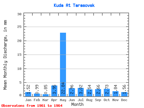
| Statistic | Jan | Feb | Mar | Apr | May | Jun | Jul | Aug | Sep | Oct | Nov | Dec | Annual |
|---|---|---|---|---|---|---|---|---|---|---|---|---|---|
| Mean | 1.51 | 1.00 | 0.86 | 3.95 | 22.83 | 2.95 | 3.03 | 2.54 | 2.66 | 2.73 | 1.84 | 1.56 | 39.01 |
| Standard Deviation | 0.77 | 0.39 | 0.34 | 1.69 | 12.85 | 0.63 | 0.38 | 0.43 | 0.67 | 0.93 | 0.75 | 0.65 | 4.58 |
| Min | 0.92 | 0.62 | 0.49 | 2.01 | 14.47 | 2.23 | 2.77 | 2.15 | 2.01 | 2.08 | 1.27 | 1.08 | 35.77 |
| Max | 2.39 | 1.40 | 1.15 | 5.14 | 37.63 | 3.43 | 3.46 | 3.00 | 3.35 | 3.39 | 2.68 | 2.31 | 42.25 |
| Coefficient of Variation | 0.51 | 0.39 | 0.39 | 0.43 | 0.56 | 0.21 | 0.12 | 0.17 | 0.25 | 0.34 | 0.41 | 0.42 | 0.12 |
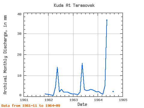
| Year | Jan | Feb | Mar | Apr | May | Jun | Jul | Aug | Sep | Oct | Nov | Dec | Annual | 1961 | 1.27 | 1.08 | 1962 | 0.92 | 0.62 | 0.49 | 4.69 | 14.47 | 2.23 | 3.46 | 2.15 | 2.01 | 2.08 | 1.56 | 1.31 | 35.77 | 1963 | 1.23 | 0.98 | 0.92 | 2.01 | 16.39 | 3.43 | 2.85 | 3.00 | 3.35 | 3.39 | 2.68 | 2.31 | 42.25 | 1964 | 2.39 | 1.40 | 1.15 | 5.14 | 37.63 | 3.20 | 2.77 | 2.46 | 2.61 |
|---|
 Return to R-Arctic Net Home Page