|
|
|||||||||||||||||
| Point ID: 8175 | Downloads | Plots | Site Data | Code: 8146 |
|
|
|||||||||||||||||
| Download | |
|---|---|
| Site Descriptor Information | Site Time Series Data |
| Link to all available data | |
|
|
| View: | Statistics | Time Series |
| Units: | mm |
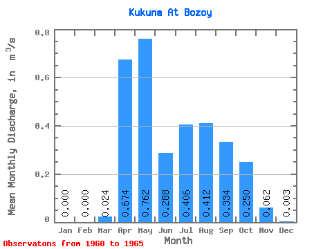
| Statistic | Jan | Feb | Mar | Apr | May | Jun | Jul | Aug | Sep | Oct | Nov | Dec | Annual |
|---|---|---|---|---|---|---|---|---|---|---|---|---|---|
| Mean | 0.00 | 0.00 | 0.02 | 0.67 | 0.76 | 0.29 | 0.41 | 0.41 | 0.33 | 0.25 | 0.06 | 0.00 | 0.27 |
| Standard Deviation | 0.00 | 0.00 | 0.05 | 0.37 | 0.56 | 0.34 | 0.30 | 0.28 | 0.19 | 0.13 | 0.06 | 0.01 | 0.12 |
| Min | 0.00 | 0.00 | 0.00 | 0.15 | 0.34 | 0.02 | 0.08 | 0.13 | 0.15 | 0.11 | 0.01 | 0.00 | 0.08 |
| Max | 0.00 | 0.00 | 0.12 | 1.10 | 1.71 | 0.85 | 0.85 | 0.69 | 0.58 | 0.39 | 0.15 | 0.02 | 0.41 |
| Coefficient of Variation | 2.24 | 0.54 | 0.73 | 1.19 | 0.75 | 0.67 | 0.57 | 0.51 | 0.93 | 2.45 | 0.45 |
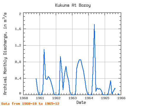
| Year | Jan | Feb | Mar | Apr | May | Jun | Jul | Aug | Sep | Oct | Nov | Dec | Annual | 1960 | 0.39 | 0.11 | 0.00 | 1961 | 0.00 | 0.00 | 0.12 | 1.10 | 0.39 | 0.37 | 0.44 | 0.40 | 0.32 | 0.19 | 0.02 | 0.00 | 0.28 | 1962 | 0.00 | 0.00 | 0.00 | 0.93 | 0.60 | 0.12 | 0.50 | 0.69 | 0.47 | 0.34 | 0.07 | 0.00 | 0.31 | 1963 | 0.00 | 0.00 | 0.00 | 0.63 | 0.77 | 0.85 | 0.85 | 0.69 | 0.58 | 0.36 | 0.15 | 0.02 | 0.41 | 1964 | 0.00 | 0.00 | 0.00 | 0.56 | 1.71 | 0.08 | 0.16 | 0.13 | 0.15 | 0.11 | 0.01 | 0.00 | 0.24 | 1965 | 0.00 | 0.00 | 0.00 | 0.15 | 0.34 | 0.02 | 0.08 | 0.15 | 0.15 | 0.11 | 0.01 | 0.00 | 0.08 |
|---|
 Return to R-Arctic Net Home Page