|
|
|||||||||||||||||
| Point ID: 8175 | Downloads | Plots | Site Data | Code: 8146 |
|
|
|||||||||||||||||
| Download | |
|---|---|
| Site Descriptor Information | Site Time Series Data |
| Link to all available data | |
|
|
| View: | Statistics | Time Series |
| Units: | m3/s |
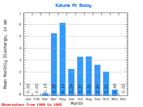
| Statistic | Jan | Feb | Mar | Apr | May | Jun | Jul | Aug | Sep | Oct | Nov | Dec | Annual |
|---|---|---|---|---|---|---|---|---|---|---|---|---|---|
| Mean | 0.00 | 0.00 | 0.19 | 5.25 | 6.13 | 2.24 | 3.27 | 3.31 | 2.60 | 2.01 | 0.48 | 0.02 | 25.10 |
| Standard Deviation | 0.00 | 0.00 | 0.43 | 2.85 | 4.48 | 2.66 | 2.46 | 2.21 | 1.49 | 1.03 | 0.45 | 0.06 | 11.20 |
| Min | 0.00 | 0.00 | 0.00 | 1.17 | 2.73 | 0.16 | 0.65 | 1.04 | 1.17 | 0.89 | 0.08 | 0.00 | 7.99 |
| Max | 0.00 | 0.00 | 0.96 | 8.56 | 13.75 | 6.62 | 6.84 | 5.55 | 4.51 | 3.14 | 1.17 | 0.14 | 38.68 |
| Coefficient of Variation | 2.24 | 0.54 | 0.73 | 1.19 | 0.75 | 0.67 | 0.57 | 0.51 | 0.93 | 2.45 | 0.45 |
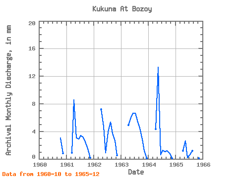
| Year | Jan | Feb | Mar | Apr | May | Jun | Jul | Aug | Sep | Oct | Nov | Dec | Annual | 1960 | 3.14 | 0.86 | 0.00 | 1961 | 0.00 | 0.00 | 0.96 | 8.56 | 3.14 | 2.88 | 3.54 | 3.22 | 2.49 | 1.53 | 0.18 | 0.00 | 26.48 | 1962 | 0.00 | 0.00 | 0.00 | 7.24 | 4.83 | 0.93 | 4.02 | 5.55 | 3.66 | 2.73 | 0.54 | 0.00 | 29.37 | 1963 | 0.00 | 0.00 | 0.00 | 4.90 | 6.19 | 6.62 | 6.84 | 5.55 | 4.51 | 2.90 | 1.17 | 0.14 | 38.68 | 1964 | 0.00 | 0.00 | 0.00 | 4.36 | 13.75 | 0.62 | 1.29 | 1.04 | 1.17 | 0.89 | 0.09 | 0.00 | 23.00 | 1965 | 0.00 | 0.00 | 0.00 | 1.17 | 2.73 | 0.16 | 0.65 | 1.21 | 1.17 | 0.89 | 0.08 | 0.00 | 7.99 |
|---|
 Return to R-Arctic Net Home Page