|
|
|||||||||||||||||
| Point ID: 8151 | Downloads | Plots | Site Data | Code: 8029 |
|
|
|||||||||||||||||
| Download | |
|---|---|
| Site Descriptor Information | Site Time Series Data |
| Link to all available data | |
|
|
| View: | Statistics | Time Series |
| Units: | mm |
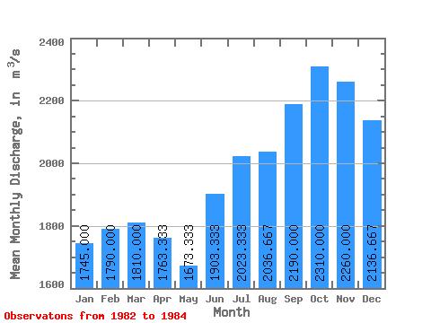
| Statistic | Jan | Feb | Mar | Apr | May | Jun | Jul | Aug | Sep | Oct | Nov | Dec | Annual |
|---|---|---|---|---|---|---|---|---|---|---|---|---|---|
| Mean | 1745.00 | 1790.00 | 1810.00 | 1763.33 | 1673.33 | 1903.33 | 2023.33 | 2036.67 | 2190.00 | 2310.00 | 2260.00 | 2136.67 | 2107.50 |
| Standard Deviation | 176.78 | 28.29 | 268.70 | 319.74 | 105.04 | 250.07 | 155.03 | 321.92 | 464.87 | 620.73 | 672.24 | 582.87 | 41.25 |
| Min | 1620.00 | 1770.00 | 1620.00 | 1480.00 | 1570.00 | 1650.00 | 1870.00 | 1760.00 | 1790.00 | 1600.00 | 1490.00 | 1590.00 | 2078.33 |
| Max | 1870.00 | 1810.00 | 2000.00 | 2110.00 | 1780.00 | 2150.00 | 2180.00 | 2390.00 | 2700.00 | 2750.00 | 2730.00 | 2750.00 | 2136.67 |
| Coefficient of Variation | 0.10 | 0.02 | 0.15 | 0.18 | 0.06 | 0.13 | 0.08 | 0.16 | 0.21 | 0.27 | 0.30 | 0.27 | 0.02 |
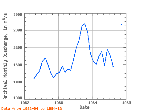
| Year | Jan | Feb | Mar | Apr | May | Jun | Jul | Aug | Sep | Oct | Nov | Dec | Annual | 1982 | 1480.00 | 1570.00 | 1650.00 | 1870.00 | 1960.00 | 1790.00 | 1600.00 | 1490.00 | 1590.00 | 1983 | 1620.00 | 1770.00 | 1620.00 | 1700.00 | 1670.00 | 1910.00 | 2180.00 | 2390.00 | 2700.00 | 2750.00 | 2560.00 | 2070.00 | 2078.33 | 1984 | 1870.00 | 1810.00 | 2000.00 | 2110.00 | 1780.00 | 2150.00 | 2020.00 | 1760.00 | 2080.00 | 2580.00 | 2730.00 | 2750.00 | 2136.67 |
|---|
 Return to R-Arctic Net Home Page