|
|
|||||||||||||||||
| Point ID: 8151 | Downloads | Plots | Site Data | Code: 8029 |
|
|
|||||||||||||||||
| Download | |
|---|---|
| Site Descriptor Information | Site Time Series Data |
| Link to all available data | |
|
|
| View: | Statistics | Time Series |
| Units: | m3/s |
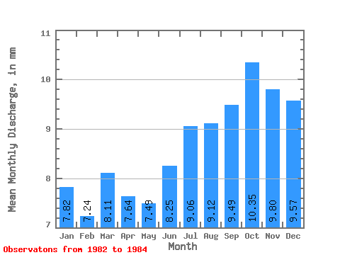
| Statistic | Jan | Feb | Mar | Apr | May | Jun | Jul | Aug | Sep | Oct | Nov | Dec | Annual |
|---|---|---|---|---|---|---|---|---|---|---|---|---|---|
| Mean | 7.81 | 7.30 | 8.11 | 7.64 | 7.49 | 8.25 | 9.06 | 9.12 | 9.49 | 10.35 | 9.80 | 9.57 | 111.22 |
| Standard Deviation | 0.79 | 0.12 | 1.20 | 1.39 | 0.47 | 1.08 | 0.69 | 1.44 | 2.02 | 2.78 | 2.91 | 2.61 | 2.18 |
| Min | 7.25 | 7.22 | 7.25 | 6.42 | 7.03 | 7.15 | 8.37 | 7.88 | 7.76 | 7.17 | 6.46 | 7.12 | 109.69 |
| Max | 8.37 | 7.38 | 8.96 | 9.15 | 7.97 | 9.32 | 9.76 | 10.70 | 11.70 | 12.31 | 11.83 | 12.31 | 112.77 |
| Coefficient of Variation | 0.10 | 0.02 | 0.15 | 0.18 | 0.06 | 0.13 | 0.08 | 0.16 | 0.21 | 0.27 | 0.30 | 0.27 | 0.02 |
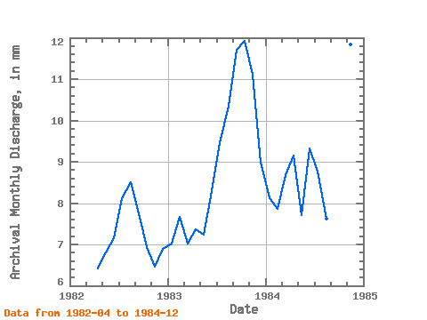
| Year | Jan | Feb | Mar | Apr | May | Jun | Jul | Aug | Sep | Oct | Nov | Dec | Annual | 1982 | 6.42 | 7.03 | 7.15 | 8.37 | 8.78 | 7.76 | 7.17 | 6.46 | 7.12 | 1983 | 7.25 | 7.22 | 7.25 | 7.37 | 7.48 | 8.28 | 9.76 | 10.70 | 11.70 | 12.31 | 11.10 | 9.27 | 109.69 | 1984 | 8.37 | 7.38 | 8.96 | 9.15 | 7.97 | 9.32 | 9.05 | 7.88 | 9.02 | 11.55 | 11.83 | 12.31 | 112.77 |
|---|
 Return to R-Arctic Net Home Page